You are here: Home > Network List > BK - Berkeley Digital Seismograph Network Stations List
> Station HUMO Hull Mountain, OR > Earthquake Result Viewer
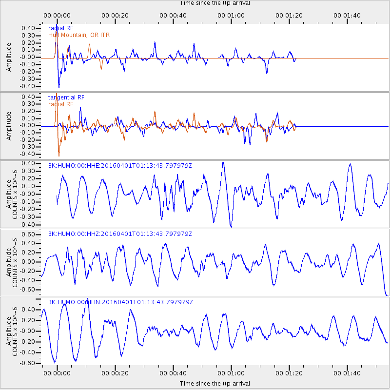
HUMO Hull Mountain, OR - Earthquake Result Viewer
*The percent match for this event was below the threshold and hence no stack was calculated.
| Earthquake location: |
South Of Mariana Islands |
| Earthquake latitude/longitude: |
12.0/143.8 |
| Earthquake time(UTC): |
2016/04/01 (092) 01:01:43 GMT |
| Earthquake Depth: |
10 km |
| Earthquake Magnitude: |
5.5 MB |
| Earthquake Catalog/Contributor: |
NEIC PDE/NEIC COMCAT |
|
| Network: |
BK Berkeley Digital Seismograph Network |
| Station: |
HUMO Hull Mountain, OR |
| Lat/Lon: |
42.61 N/122.96 W |
| Elevation: |
555 m |
|
| Distance: |
84.3 deg |
| Az: |
47.792 deg |
| Baz: |
280.971 deg |
| Ray Param: |
$rayparam |
*The percent match for this event was below the threshold and hence was not used in the summary stack. |
|
| Radial Match: |
63.037697 % |
| Radial Bump: |
400 |
| Transverse Match: |
69.61283 % |
| Transverse Bump: |
216 |
| SOD ConfigId: |
1475611 |
| Insert Time: |
2016-04-15 01:03:34.350 +0000 |
| GWidth: |
2.5 |
| Max Bumps: |
400 |
| Tol: |
0.001 |
|
Signal To Noise
| Channel | StoN | STA | LTA |
| BK:HUMO:00:HHZ:20160401T01:13:43.797979Z | 1.058029 | 1.8049731E-7 | 1.7059769E-7 |
| BK:HUMO:00:HHN:20160401T01:13:43.797979Z | 2.2503088 | 3.9033168E-7 | 1.7345694E-7 |
| BK:HUMO:00:HHE:20160401T01:13:43.797979Z | 0.65872616 | 1.0462579E-7 | 1.5883047E-7 |
| Arrivals |
| Ps | |
| PpPs | |
| PsPs/PpSs | |


