You are here: Home > Network List > II - Global Seismograph Network (GSN - IRIS/IDA) Stations List
> Station WRAB Tennant Creek, NT, Australia > Earthquake Result Viewer
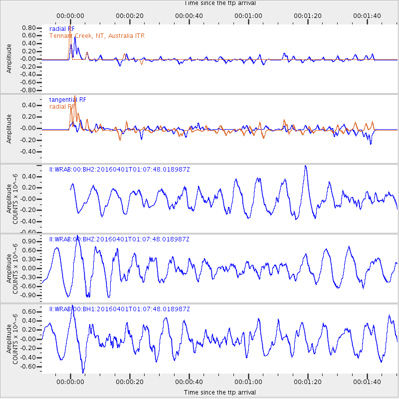
WRAB Tennant Creek, NT, Australia - Earthquake Result Viewer
*The percent match for this event was below the threshold and hence no stack was calculated.
| Earthquake location: |
South Of Mariana Islands |
| Earthquake latitude/longitude: |
12.0/143.8 |
| Earthquake time(UTC): |
2016/04/01 (092) 01:01:43 GMT |
| Earthquake Depth: |
10 km |
| Earthquake Magnitude: |
5.5 MB |
| Earthquake Catalog/Contributor: |
NEIC PDE/NEIC COMCAT |
|
| Network: |
II Global Seismograph Network (GSN - IRIS/IDA) |
| Station: |
WRAB Tennant Creek, NT, Australia |
| Lat/Lon: |
19.93 S/134.36 E |
| Elevation: |
366 m |
|
| Distance: |
33.1 deg |
| Az: |
196.474 deg |
| Baz: |
17.154 deg |
| Ray Param: |
$rayparam |
*The percent match for this event was below the threshold and hence was not used in the summary stack. |
|
| Radial Match: |
75.83437 % |
| Radial Bump: |
400 |
| Transverse Match: |
70.04837 % |
| Transverse Bump: |
400 |
| SOD ConfigId: |
1475611 |
| Insert Time: |
2016-04-15 01:10:58.375 +0000 |
| GWidth: |
2.5 |
| Max Bumps: |
400 |
| Tol: |
0.001 |
|
Signal To Noise
| Channel | StoN | STA | LTA |
| II:WRAB:00:BHZ:20160401T01:07:48.018987Z | 1.711742 | 6.933065E-7 | 4.050298E-7 |
| II:WRAB:00:BH1:20160401T01:07:48.018987Z | 1.3977419 | 4.5108536E-7 | 3.227244E-7 |
| II:WRAB:00:BH2:20160401T01:07:48.018987Z | 0.77786195 | 1.2174696E-7 | 1.5651487E-7 |
| Arrivals |
| Ps | |
| PpPs | |
| PsPs/PpSs | |


