You are here: Home > Network List > IU - Global Seismograph Network (GSN - IRIS/USGS) Stations List
> Station XMAS Kiritimati Island, Republic of Kiribati > Earthquake Result Viewer
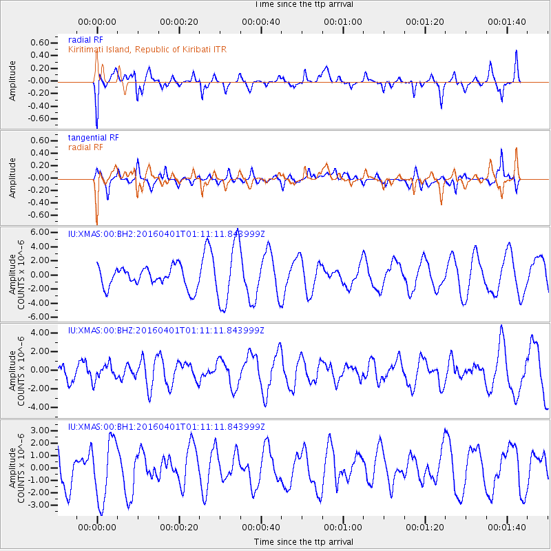
XMAS Kiritimati Island, Republic of Kiribati - Earthquake Result Viewer
*The percent match for this event was below the threshold and hence no stack was calculated.
| Earthquake location: |
South Of Mariana Islands |
| Earthquake latitude/longitude: |
12.0/143.8 |
| Earthquake time(UTC): |
2016/04/01 (092) 01:01:43 GMT |
| Earthquake Depth: |
10 km |
| Earthquake Magnitude: |
5.5 MB |
| Earthquake Catalog/Contributor: |
NEIC PDE/NEIC COMCAT |
|
| Network: |
IU Global Seismograph Network (GSN - IRIS/USGS) |
| Station: |
XMAS Kiritimati Island, Republic of Kiribati |
| Lat/Lon: |
2.04 N/157.45 W |
| Elevation: |
20 m |
|
| Distance: |
59.0 deg |
| Az: |
94.841 deg |
| Baz: |
282.68 deg |
| Ray Param: |
$rayparam |
*The percent match for this event was below the threshold and hence was not used in the summary stack. |
|
| Radial Match: |
69.47107 % |
| Radial Bump: |
339 |
| Transverse Match: |
57.963947 % |
| Transverse Bump: |
400 |
| SOD ConfigId: |
1475611 |
| Insert Time: |
2016-04-15 01:11:44.307 +0000 |
| GWidth: |
2.5 |
| Max Bumps: |
400 |
| Tol: |
0.001 |
|
Signal To Noise
| Channel | StoN | STA | LTA |
| IU:XMAS:00:BHZ:20160401T01:11:11.843999Z | 0.7815719 | 8.3562895E-7 | 1.0691646E-6 |
| IU:XMAS:00:BH1:20160401T01:11:11.843999Z | 2.3118916 | 2.5421998E-6 | 1.099619E-6 |
| IU:XMAS:00:BH2:20160401T01:11:11.843999Z | 3.1287506 | 4.4038325E-6 | 1.4075371E-6 |
| Arrivals |
| Ps | |
| PpPs | |
| PsPs/PpSs | |


