You are here: Home > Network List > CI - Caltech Regional Seismic Network Stations List
> Station MPM Manuel Prospect Mine, California, USA > Earthquake Result Viewer
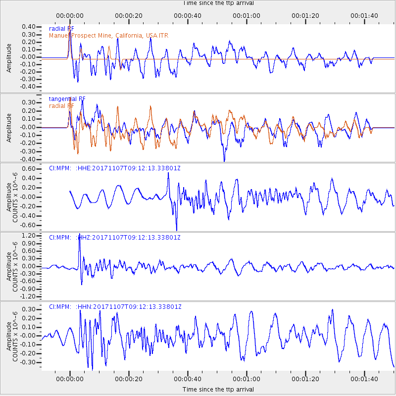
MPM Manuel Prospect Mine, California, USA - Earthquake Result Viewer
*The percent match for this event was below the threshold and hence no stack was calculated.
| Earthquake location: |
Fiji Islands Region |
| Earthquake latitude/longitude: |
-17.7/-178.5 |
| Earthquake time(UTC): |
2017/11/07 (311) 09:01:39 GMT |
| Earthquake Depth: |
555 km |
| Earthquake Magnitude: |
5.7 Mww |
| Earthquake Catalog/Contributor: |
NEIC PDE/us |
|
| Network: |
CI Caltech Regional Seismic Network |
| Station: |
MPM Manuel Prospect Mine, California, USA |
| Lat/Lon: |
36.06 N/117.49 W |
| Elevation: |
185 m |
|
| Distance: |
78.6 deg |
| Az: |
46.321 deg |
| Baz: |
238.31 deg |
| Ray Param: |
$rayparam |
*The percent match for this event was below the threshold and hence was not used in the summary stack. |
|
| Radial Match: |
59.633533 % |
| Radial Bump: |
400 |
| Transverse Match: |
63.956993 % |
| Transverse Bump: |
400 |
| SOD ConfigId: |
13570011 |
| Insert Time: |
2019-04-29 03:34:13.260 +0000 |
| GWidth: |
2.5 |
| Max Bumps: |
400 |
| Tol: |
0.001 |
|
Signal To Noise
| Channel | StoN | STA | LTA |
| CI:MPM: :HHZ:20171107T09:12:13.33801Z | 4.459074 | 3.87094E-7 | 8.6810395E-8 |
| CI:MPM: :HHN:20171107T09:12:13.33801Z | 1.4986112 | 1.2011608E-7 | 8.0151594E-8 |
| CI:MPM: :HHE:20171107T09:12:13.33801Z | 1.1264538 | 1.5307778E-7 | 1.3589353E-7 |
| Arrivals |
| Ps | |
| PpPs | |
| PsPs/PpSs | |


