You are here: Home > Network List > TA - USArray Transportable Network (new EarthScope stations) Stations List
> Station TOLK Toolik Lake Research Station, AK, USA > Earthquake Result Viewer
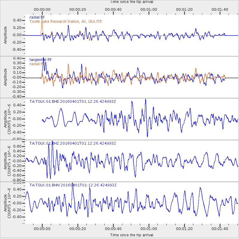
TOLK Toolik Lake Research Station, AK, USA - Earthquake Result Viewer
*The percent match for this event was below the threshold and hence no stack was calculated.
| Earthquake location: |
South Of Mariana Islands |
| Earthquake latitude/longitude: |
12.0/143.8 |
| Earthquake time(UTC): |
2016/04/01 (092) 01:01:43 GMT |
| Earthquake Depth: |
10 km |
| Earthquake Magnitude: |
5.5 MB |
| Earthquake Catalog/Contributor: |
NEIC PDE/NEIC COMCAT |
|
| Network: |
TA USArray Transportable Network (new EarthScope stations) |
| Station: |
TOLK Toolik Lake Research Station, AK, USA |
| Lat/Lon: |
68.64 N/149.57 W |
| Elevation: |
760 m |
|
| Distance: |
70.5 deg |
| Az: |
20.9 deg |
| Baz: |
252.338 deg |
| Ray Param: |
$rayparam |
*The percent match for this event was below the threshold and hence was not used in the summary stack. |
|
| Radial Match: |
65.80212 % |
| Radial Bump: |
400 |
| Transverse Match: |
66.578354 % |
| Transverse Bump: |
395 |
| SOD ConfigId: |
1475611 |
| Insert Time: |
2016-04-15 01:13:07.871 +0000 |
| GWidth: |
2.5 |
| Max Bumps: |
400 |
| Tol: |
0.001 |
|
Signal To Noise
| Channel | StoN | STA | LTA |
| TA:TOLK:01:BHZ:20160401T01:12:26.424993Z | 2.355028 | 3.3440867E-7 | 1.4199775E-7 |
| TA:TOLK:01:BHN:20160401T01:12:26.424993Z | 0.5134711 | 1.0151378E-7 | 1.9770106E-7 |
| TA:TOLK:01:BHE:20160401T01:12:26.424993Z | 1.0879164 | 1.4297089E-7 | 1.3141717E-7 |
| Arrivals |
| Ps | |
| PpPs | |
| PsPs/PpSs | |


