You are here: Home > Network List > TA - USArray Transportable Network (new EarthScope stations) Stations List
> Station 109C Camp Elliot, Mirimar, CA, USA > Earthquake Result Viewer
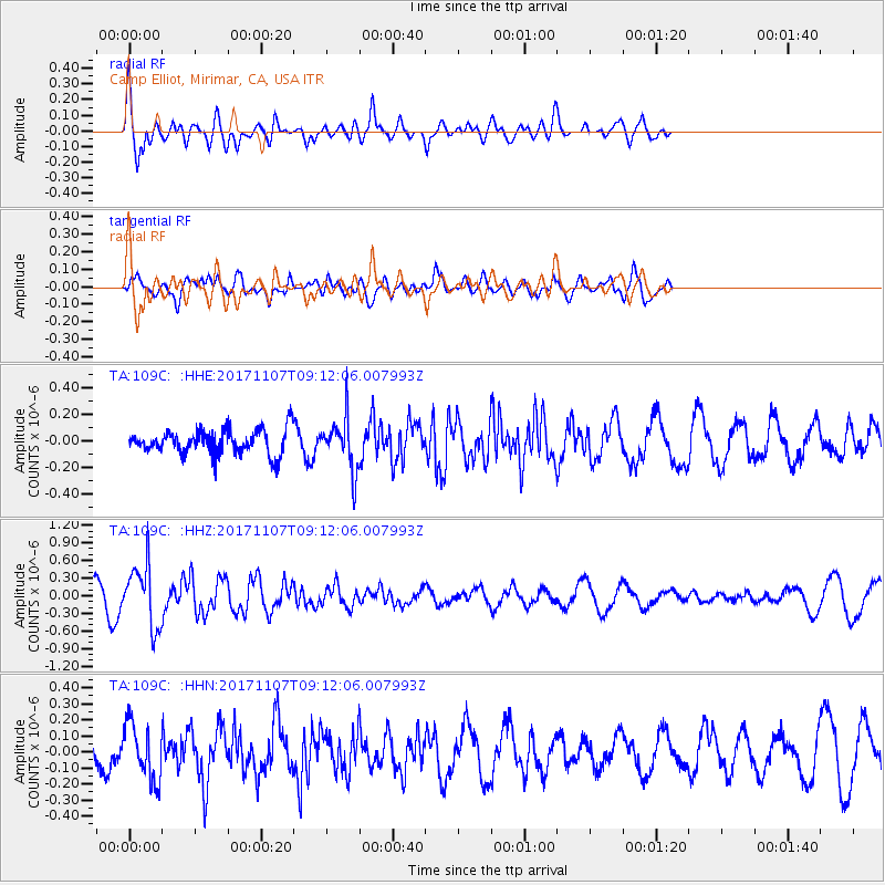
109C Camp Elliot, Mirimar, CA, USA - Earthquake Result Viewer
*The percent match for this event was below the threshold and hence no stack was calculated.
| Earthquake location: |
Fiji Islands Region |
| Earthquake latitude/longitude: |
-17.7/-178.5 |
| Earthquake time(UTC): |
2017/11/07 (311) 09:01:39 GMT |
| Earthquake Depth: |
555 km |
| Earthquake Magnitude: |
5.7 Mww |
| Earthquake Catalog/Contributor: |
NEIC PDE/us |
|
| Network: |
TA USArray Transportable Network (new EarthScope stations) |
| Station: |
109C Camp Elliot, Mirimar, CA, USA |
| Lat/Lon: |
32.89 N/117.11 W |
| Elevation: |
150 m |
|
| Distance: |
77.3 deg |
| Az: |
49.252 deg |
| Baz: |
239.138 deg |
| Ray Param: |
$rayparam |
*The percent match for this event was below the threshold and hence was not used in the summary stack. |
|
| Radial Match: |
72.1437 % |
| Radial Bump: |
400 |
| Transverse Match: |
58.274403 % |
| Transverse Bump: |
400 |
| SOD ConfigId: |
13570011 |
| Insert Time: |
2019-04-29 03:36:54.258 +0000 |
| GWidth: |
2.5 |
| Max Bumps: |
400 |
| Tol: |
0.001 |
|
Signal To Noise
| Channel | StoN | STA | LTA |
| TA:109C: :HHZ:20171107T09:12:06.007993Z | 3.3608882 | 5.315096E-7 | 1.5814558E-7 |
| TA:109C: :HHN:20171107T09:12:06.007993Z | 1.3859159 | 1.7495431E-7 | 1.2623732E-7 |
| TA:109C: :HHE:20171107T09:12:06.007993Z | 2.158086 | 1.9619968E-7 | 9.0913744E-8 |
| Arrivals |
| Ps | |
| PpPs | |
| PsPs/PpSs | |


