You are here: Home > Network List > TA - USArray Transportable Network (new EarthScope stations) Stations List
> Station 833A Chaparral WMA, Artesia Wells, TX, USA > Earthquake Result Viewer
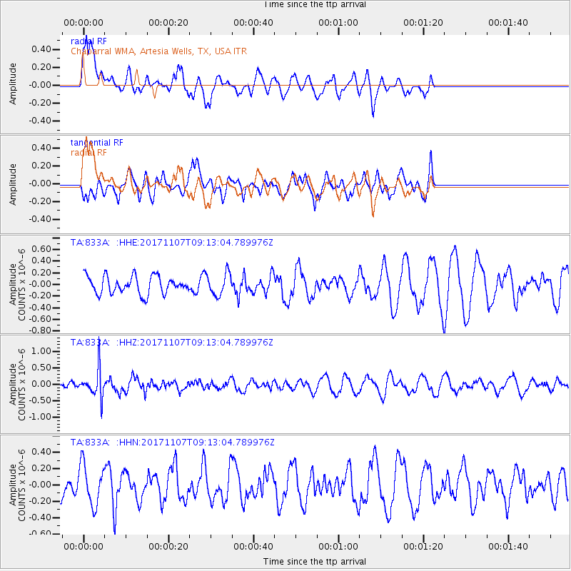
833A Chaparral WMA, Artesia Wells, TX, USA - Earthquake Result Viewer
*The percent match for this event was below the threshold and hence no stack was calculated.
| Earthquake location: |
Fiji Islands Region |
| Earthquake latitude/longitude: |
-17.7/-178.5 |
| Earthquake time(UTC): |
2017/11/07 (311) 09:01:39 GMT |
| Earthquake Depth: |
555 km |
| Earthquake Magnitude: |
5.7 Mww |
| Earthquake Catalog/Contributor: |
NEIC PDE/us |
|
| Network: |
TA USArray Transportable Network (new EarthScope stations) |
| Station: |
833A Chaparral WMA, Artesia Wells, TX, USA |
| Lat/Lon: |
28.32 N/99.39 W |
| Elevation: |
171 m |
|
| Distance: |
89.1 deg |
| Az: |
59.99 deg |
| Baz: |
249.458 deg |
| Ray Param: |
$rayparam |
*The percent match for this event was below the threshold and hence was not used in the summary stack. |
|
| Radial Match: |
45.887947 % |
| Radial Bump: |
380 |
| Transverse Match: |
47.989094 % |
| Transverse Bump: |
346 |
| SOD ConfigId: |
13570011 |
| Insert Time: |
2019-04-29 03:36:54.314 +0000 |
| GWidth: |
2.5 |
| Max Bumps: |
400 |
| Tol: |
0.001 |
|
Signal To Noise
| Channel | StoN | STA | LTA |
| TA:833A: :HHZ:20171107T09:13:04.789976Z | 2.8418088 | 4.3647836E-7 | 1.5359176E-7 |
| TA:833A: :HHN:20171107T09:13:04.789976Z | 1.1359212 | 2.5295208E-7 | 2.2268452E-7 |
| TA:833A: :HHE:20171107T09:13:04.789976Z | 1.280402 | 1.9199722E-7 | 1.4995074E-7 |
| Arrivals |
| Ps | |
| PpPs | |
| PsPs/PpSs | |


