You are here: Home > Network List > TA - USArray Transportable Network (new EarthScope stations) Stations List
> Station MSTX Muleshoe, TX, USA > Earthquake Result Viewer
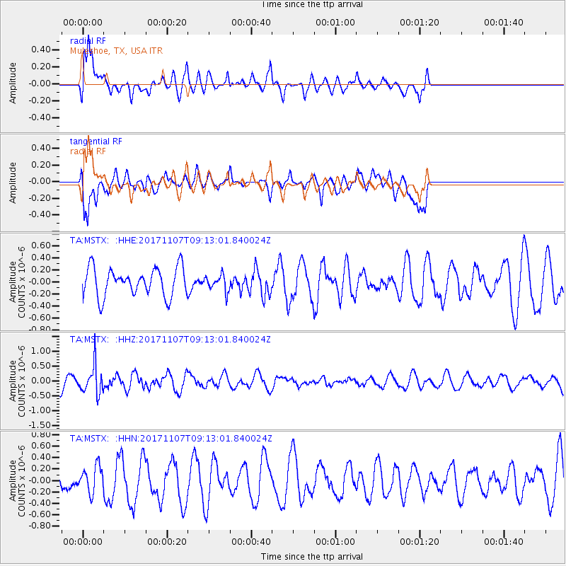
MSTX Muleshoe, TX, USA - Earthquake Result Viewer
*The percent match for this event was below the threshold and hence no stack was calculated.
| Earthquake location: |
Fiji Islands Region |
| Earthquake latitude/longitude: |
-17.7/-178.5 |
| Earthquake time(UTC): |
2017/11/07 (311) 09:01:39 GMT |
| Earthquake Depth: |
555 km |
| Earthquake Magnitude: |
5.7 Mww |
| Earthquake Catalog/Contributor: |
NEIC PDE/us |
|
| Network: |
TA USArray Transportable Network (new EarthScope stations) |
| Station: |
MSTX Muleshoe, TX, USA |
| Lat/Lon: |
33.97 N/102.77 W |
| Elevation: |
1167 m |
|
| Distance: |
88.5 deg |
| Az: |
53.692 deg |
| Baz: |
247.581 deg |
| Ray Param: |
$rayparam |
*The percent match for this event was below the threshold and hence was not used in the summary stack. |
|
| Radial Match: |
62.896797 % |
| Radial Bump: |
400 |
| Transverse Match: |
59.622574 % |
| Transverse Bump: |
400 |
| SOD ConfigId: |
13570011 |
| Insert Time: |
2019-04-29 03:37:21.589 +0000 |
| GWidth: |
2.5 |
| Max Bumps: |
400 |
| Tol: |
0.001 |
|
Signal To Noise
| Channel | StoN | STA | LTA |
| TA:MSTX: :HHZ:20171107T09:13:01.840024Z | 1.4928275 | 4.909328E-7 | 3.28861E-7 |
| TA:MSTX: :HHN:20171107T09:13:01.840024Z | 0.796081 | 2.3356165E-7 | 2.9338932E-7 |
| TA:MSTX: :HHE:20171107T09:13:01.840024Z | 0.5728117 | 1.348795E-7 | 2.3546917E-7 |
| Arrivals |
| Ps | |
| PpPs | |
| PsPs/PpSs | |


