You are here: Home > Network List > AU - Australian Seismological Centre Stations List
> Station MORW Morawa, Western Australia > Earthquake Result Viewer
MORW Morawa, Western Australia - Earthquake Result Viewer
| Earthquake location: |
New Guinea, Papua New Guinea |
| Earthquake latitude/longitude: |
-4.2/143.5 |
| Earthquake time(UTC): |
2017/11/07 (311) 21:26:38 GMT |
| Earthquake Depth: |
107 km |
| Earthquake Magnitude: |
6.5 mww |
| Earthquake Catalog/Contributor: |
NEIC PDE/us |
|
| Network: |
AU Australian Seismological Centre |
| Station: |
MORW Morawa, Western Australia |
| Lat/Lon: |
29.07 S/116.04 E |
| Elevation: |
296 m |
|
| Distance: |
35.9 deg |
| Az: |
223.495 deg |
| Baz: |
51.64 deg |
| Ray Param: |
0.076631464 |
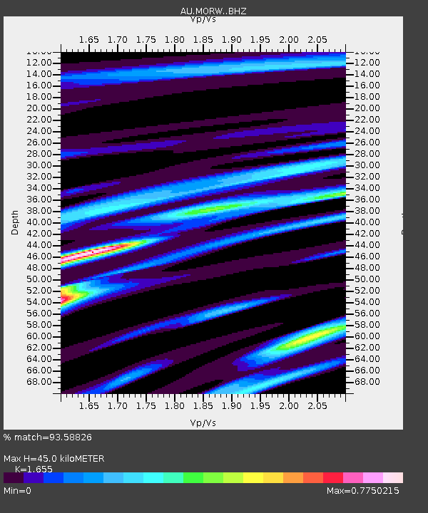
| Estimated Moho Depth: |
45.0 km |
| Estimated Crust Vp/Vs: |
1.65 |
| Assumed Crust Vp: |
6.459 km/s |
| Estimated Crust Vs: |
3.903 km/s |
| Estimated Crust Poisson's Ratio: |
0.21 |
|
| Radial Match: |
93.58826 % |
| Radial Bump: |
307 |
| Transverse Match: |
73.19742 % |
| Transverse Bump: |
400 |
| SOD ConfigId: |
13570011 |
| Insert Time: |
2019-04-29 03:40:22.499 +0000 |
| GWidth: |
2.5 |
| Max Bumps: |
400 |
| Tol: |
0.001 |
|

Signal To Noise
| Channel | StoN | STA | LTA |
| AU:MORW: :BHZ:20171107T21:32:57.418999Z | 26.458298 | 5.7099896E-6 | 2.1581093E-7 |
| AU:MORW: :BHN:20171107T21:32:57.418999Z | 30.867329 | 2.4911508E-6 | 8.07051E-8 |
| AU:MORW: :BHE:20171107T21:32:57.418999Z | 16.303944 | 2.8070417E-6 | 1.7216949E-7 |
| Arrivals |
| Ps | 4.9 SECOND |
| PpPs | 17 SECOND |
| PsPs/PpSs | 22 SECOND |


