You are here: Home > Network List > TA - USArray Transportable Network (new EarthScope stations) Stations List
> Station F18A Big Timber, MT, USA > Earthquake Result Viewer
F18A Big Timber, MT, USA - Earthquake Result Viewer

| Earthquake location: |
Guatemala |
| Earthquake latitude/longitude: |
14.6/-91.2 |
| Earthquake time(UTC): |
2009/05/03 (123) 16:21:47 GMT |
| Earthquake Depth: |
124 km |
| Earthquake Magnitude: |
5.6 MB, 6.2 MW, 6.2 MW |
| Earthquake Catalog/Contributor: |
WHDF/NEIC |
|
| Network: |
TA USArray Transportable Network (new EarthScope stations) |
| Station: |
F18A Big Timber, MT, USA |
| Lat/Lon: |
45.90 N/109.72 W |
| Elevation: |
1291 m |
|
| Distance: |
34.9 deg |
| Az: |
337.171 deg |
| Baz: |
147.453 deg |
| Ray Param: |
0.077083215 |
| Estimated Moho Depth: |
60.25 km |
| Estimated Crust Vp/Vs: |
1.72 |
| Assumed Crust Vp: |
6.242 km/s |
| Estimated Crust Vs: |
3.64 km/s |
| Estimated Crust Poisson's Ratio: |
0.24 |
|
| Radial Match: |
84.66396 % |
| Radial Bump: |
379 |
| Transverse Match: |
68.1812 % |
| Transverse Bump: |
400 |
| SOD ConfigId: |
2658 |
| Insert Time: |
2010-03-06 06:06:30.969 +0000 |
| GWidth: |
2.5 |
| Max Bumps: |
400 |
| Tol: |
0.001 |
|
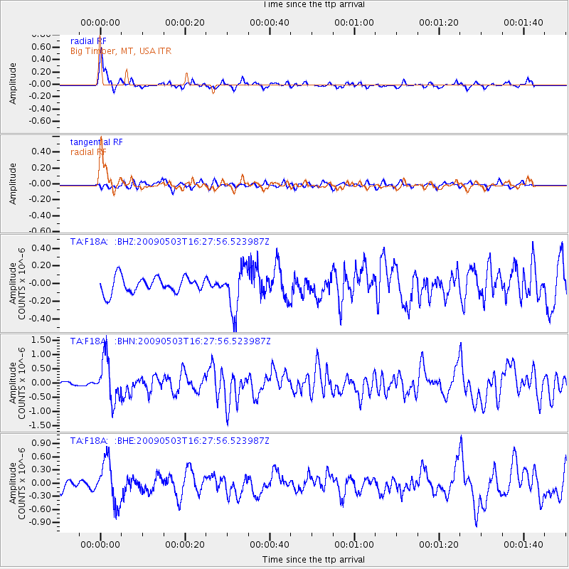
Signal To Noise
| Channel | StoN | STA | LTA |
| TA:F18A: :BHN:20090503T16:27:56.523987Z | 8.449396 | 7.555071E-7 | 8.9415515E-8 |
| TA:F18A: :BHE:20090503T16:27:56.523987Z | 4.217102 | 5.01465E-7 | 1.18912226E-7 |
| TA:F18A: :BHZ:20090503T16:27:56.523987Z | 2.7997415 | 2.4930043E-7 | 8.904408E-8 |
| Arrivals |
| Ps | 7.4 SECOND |
| PpPs | 24 SECOND |
| PsPs/PpSs | 32 SECOND |


