You are here: Home > Network List > KG - Korean Seismic Network- KIGAM Stations List
> Station TJN Taejon, Republic of Korea > Earthquake Result Viewer
TJN Taejon, Republic of Korea - Earthquake Result Viewer
| Earthquake location: |
New Guinea, Papua New Guinea |
| Earthquake latitude/longitude: |
-4.2/143.5 |
| Earthquake time(UTC): |
2017/11/07 (311) 21:26:38 GMT |
| Earthquake Depth: |
107 km |
| Earthquake Magnitude: |
6.5 mww |
| Earthquake Catalog/Contributor: |
NEIC PDE/us |
|
| Network: |
KG Korean Seismic Network- KIGAM |
| Station: |
TJN Taejon, Republic of Korea |
| Lat/Lon: |
36.38 N/127.36 E |
| Elevation: |
60 m |
|
| Distance: |
43.1 deg |
| Az: |
340.866 deg |
| Baz: |
156.105 deg |
| Ray Param: |
0.07237699 |
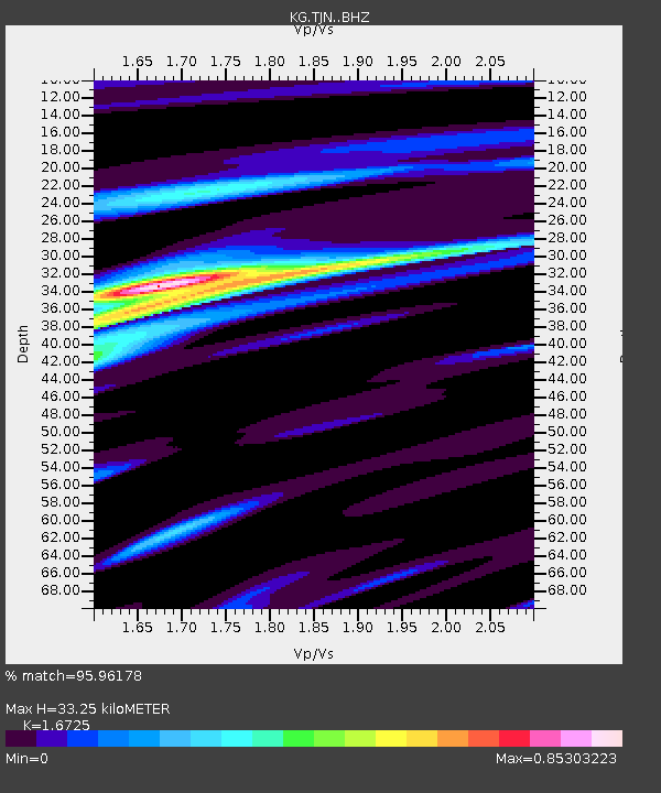
| Estimated Moho Depth: |
33.25 km |
| Estimated Crust Vp/Vs: |
1.67 |
| Assumed Crust Vp: |
6.459 km/s |
| Estimated Crust Vs: |
3.862 km/s |
| Estimated Crust Poisson's Ratio: |
0.22 |
|
| Radial Match: |
95.96178 % |
| Radial Bump: |
400 |
| Transverse Match: |
80.92597 % |
| Transverse Bump: |
400 |
| SOD ConfigId: |
13570011 |
| Insert Time: |
2019-04-29 03:42:15.786 +0000 |
| GWidth: |
2.5 |
| Max Bumps: |
400 |
| Tol: |
0.001 |
|

Signal To Noise
| Channel | StoN | STA | LTA |
| KG:TJN: :BHZ:20171107T21:33:57.519005Z | 47.25162 | 3.157752E-5 | 6.682844E-7 |
| KG:TJN: :BHN:20171107T21:33:57.519005Z | 19.482494 | 1.4791826E-5 | 7.592368E-7 |
| KG:TJN: :BHE:20171107T21:33:57.519005Z | 12.147673 | 6.4147443E-6 | 5.2806365E-7 |
| Arrivals |
| Ps | 3.7 SECOND |
| PpPs | 13 SECOND |
| PsPs/PpSs | 17 SECOND |


