You are here: Home > Network List > MM - Myanmar National Seismic Network Stations List
> Station TMU Tamu, Sagaing, Myanmar > Earthquake Result Viewer
TMU Tamu, Sagaing, Myanmar - Earthquake Result Viewer
| Earthquake location: |
New Guinea, Papua New Guinea |
| Earthquake latitude/longitude: |
-4.2/143.5 |
| Earthquake time(UTC): |
2017/11/07 (311) 21:26:38 GMT |
| Earthquake Depth: |
107 km |
| Earthquake Magnitude: |
6.5 mww |
| Earthquake Catalog/Contributor: |
NEIC PDE/us |
|
| Network: |
MM Myanmar National Seismic Network |
| Station: |
TMU Tamu, Sagaing, Myanmar |
| Lat/Lon: |
24.23 N/94.30 E |
| Elevation: |
182 m |
|
| Distance: |
55.6 deg |
| Az: |
303.119 deg |
| Baz: |
113.802 deg |
| Ray Param: |
0.064374425 |
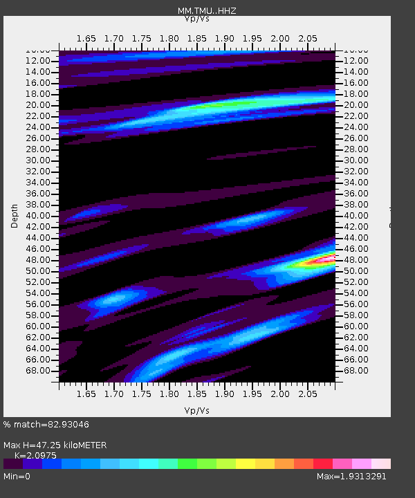
| Estimated Moho Depth: |
47.25 km |
| Estimated Crust Vp/Vs: |
2.10 |
| Assumed Crust Vp: |
6.316 km/s |
| Estimated Crust Vs: |
3.011 km/s |
| Estimated Crust Poisson's Ratio: |
0.35 |
|
| Radial Match: |
82.93046 % |
| Radial Bump: |
400 |
| Transverse Match: |
71.25355 % |
| Transverse Bump: |
400 |
| SOD ConfigId: |
13570011 |
| Insert Time: |
2019-04-29 03:42:42.181 +0000 |
| GWidth: |
2.5 |
| Max Bumps: |
400 |
| Tol: |
0.001 |
|

Signal To Noise
| Channel | StoN | STA | LTA |
| MM:TMU: :HHZ:20171107T21:35:31.997979Z | 78.72133 | 4.8511E-6 | 6.16237E-8 |
| MM:TMU: :HHN:20171107T21:35:31.997979Z | 36.701916 | 1.933681E-6 | 5.2686108E-8 |
| MM:TMU: :HHE:20171107T21:35:31.997979Z | 12.581182 | 2.802256E-6 | 2.2273393E-7 |
| Arrivals |
| Ps | 8.6 SECOND |
| PpPs | 22 SECOND |
| PsPs/PpSs | 31 SECOND |


