You are here: Home > Network List > TA - USArray Transportable Network (new EarthScope stations) Stations List
> Station B18K Kokolik River, AK, USA > Earthquake Result Viewer
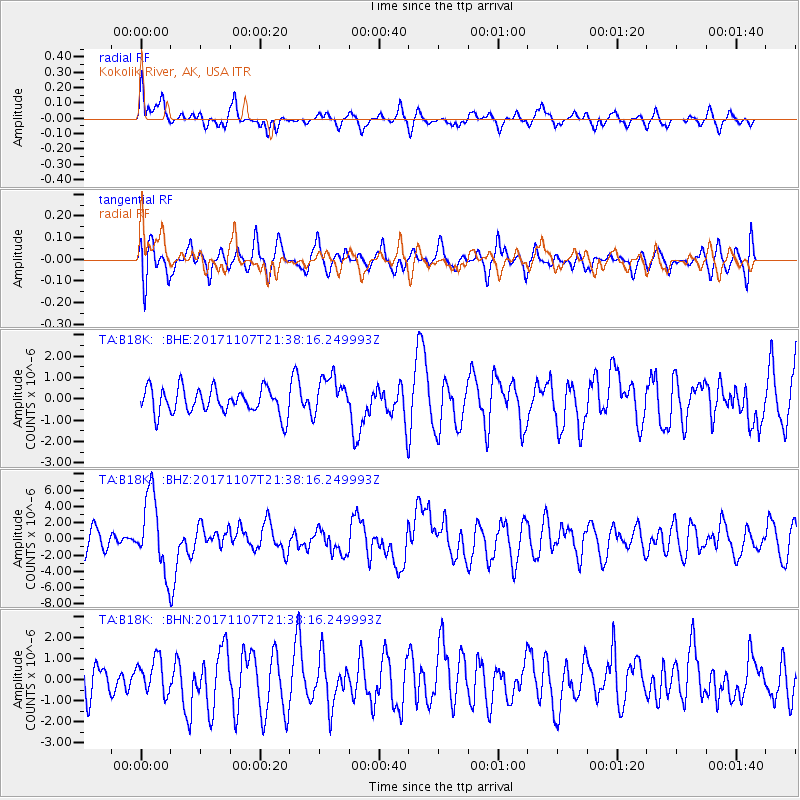
B18K Kokolik River, AK, USA - Earthquake Result Viewer
*The percent match for this event was below the threshold and hence no stack was calculated.
| Earthquake location: |
New Guinea, Papua New Guinea |
| Earthquake latitude/longitude: |
-4.2/143.5 |
| Earthquake time(UTC): |
2017/11/07 (311) 21:26:38 GMT |
| Earthquake Depth: |
107 km |
| Earthquake Magnitude: |
6.5 mww |
| Earthquake Catalog/Contributor: |
NEIC PDE/us |
|
| Network: |
TA USArray Transportable Network (new EarthScope stations) |
| Station: |
B18K Kokolik River, AK, USA |
| Lat/Lon: |
69.36 N/161.80 W |
| Elevation: |
222 m |
|
| Distance: |
82.2 deg |
| Az: |
16.983 deg |
| Baz: |
235.259 deg |
| Ray Param: |
$rayparam |
*The percent match for this event was below the threshold and hence was not used in the summary stack. |
|
| Radial Match: |
59.745323 % |
| Radial Bump: |
400 |
| Transverse Match: |
54.294384 % |
| Transverse Bump: |
400 |
| SOD ConfigId: |
13570011 |
| Insert Time: |
2019-04-29 03:43:19.319 +0000 |
| GWidth: |
2.5 |
| Max Bumps: |
400 |
| Tol: |
0.001 |
|
Signal To Noise
| Channel | StoN | STA | LTA |
| TA:B18K: :BHZ:20171107T21:38:16.249993Z | 3.5285761 | 4.6597734E-6 | 1.3205819E-6 |
| TA:B18K: :BHN:20171107T21:38:16.249993Z | 1.085083 | 8.3191037E-7 | 7.66679E-7 |
| TA:B18K: :BHE:20171107T21:38:16.249993Z | 1.5430249 | 9.2407964E-7 | 5.988754E-7 |
| Arrivals |
| Ps | |
| PpPs | |
| PsPs/PpSs | |


