You are here: Home > Network List > TA - USArray Transportable Network (new EarthScope stations) Stations List
> Station F18A Big Timber, MT, USA > Earthquake Result Viewer
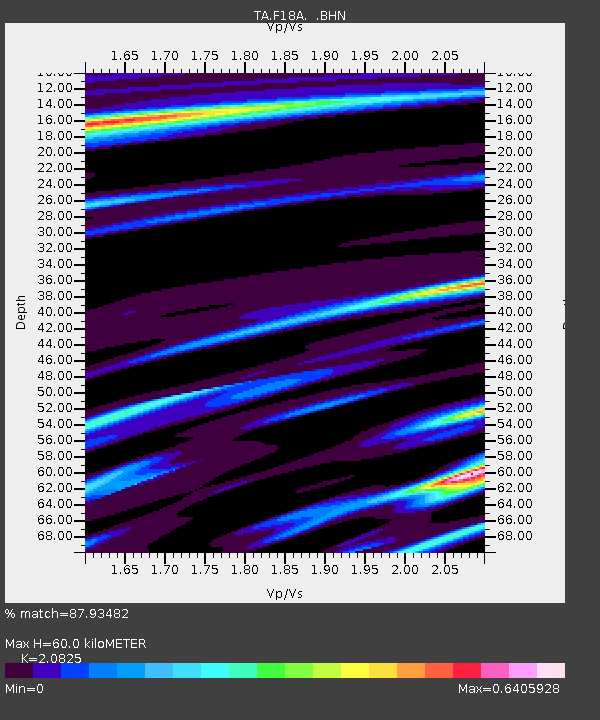
F18A Big Timber, MT, USA - Earthquake Result Viewer
| Earthquake location: |
Tonga Islands |
| Earthquake latitude/longitude: |
-20.8/-173.3 |
| Earthquake time(UTC): |
2008/06/26 (178) 21:19:15 GMT |
| Earthquake Depth: |
38 km |
| Earthquake Magnitude: |
6.0 MB, 5.8 MS, 6.2 MW, 6.1 MW |
| Earthquake Catalog/Contributor: |
WHDF/NEIC |
|
| Network: |
TA USArray Transportable Network (new EarthScope stations) |
| Station: |
F18A Big Timber, MT, USA |
| Lat/Lon: |
45.90 N/109.72 W |
| Elevation: |
1291 m |
|
| Distance: |
87.8 deg |
| Az: |
38.758 deg |
| Baz: |
237.036 deg |
| Ray Param: |
0.042987373 |
| Estimated Moho Depth: |
60.0 km |
| Estimated Crust Vp/Vs: |
2.08 |
| Assumed Crust Vp: |
6.242 km/s |
| Estimated Crust Vs: |
2.997 km/s |
| Estimated Crust Poisson's Ratio: |
0.35 |
|
| Radial Match: |
87.93482 % |
| Radial Bump: |
327 |
| Transverse Match: |
81.81756 % |
| Transverse Bump: |
287 |
| SOD ConfigId: |
2504 |
| Insert Time: |
2010-03-06 06:07:00.971 +0000 |
| GWidth: |
2.5 |
| Max Bumps: |
400 |
| Tol: |
0.001 |
|

Signal To Noise
| Channel | StoN | STA | LTA |
| TA:F18A: :BHN:20080626T21:31:29.673994Z | 16.365404 | 1.554907E-6 | 9.5011835E-8 |
| TA:F18A: :BHE:20080626T21:31:29.673994Z | 3.2254453 | 2.0540298E-7 | 6.368205E-8 |
| TA:F18A: :BHZ:20080626T21:31:29.673994Z | 2.8458374 | 2.553672E-7 | 8.973359E-8 |
| Arrivals |
| Ps | 11 SECOND |
| PpPs | 29 SECOND |
| PsPs/PpSs | 40 SECOND |


