You are here: Home > Network List > TA - USArray Transportable Network (new EarthScope stations) Stations List
> Station D23K Nanushuk River, AK USA > Earthquake Result Viewer
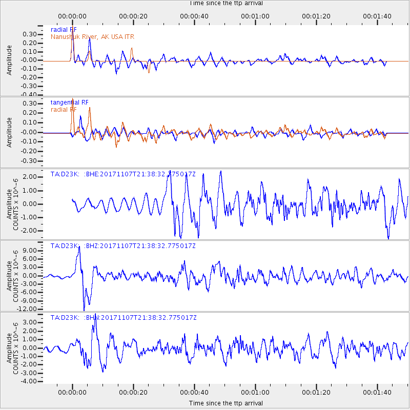
D23K Nanushuk River, AK USA - Earthquake Result Viewer
| Earthquake location: |
New Guinea, Papua New Guinea |
| Earthquake latitude/longitude: |
-4.2/143.5 |
| Earthquake time(UTC): |
2017/11/07 (311) 21:26:38 GMT |
| Earthquake Depth: |
107 km |
| Earthquake Magnitude: |
6.5 mww |
| Earthquake Catalog/Contributor: |
NEIC PDE/us |
|
| Network: |
TA USArray Transportable Network (new EarthScope stations) |
| Station: |
D23K Nanushuk River, AK USA |
| Lat/Lon: |
68.97 N/150.68 W |
| Elevation: |
406 m |
|
| Distance: |
85.5 deg |
| Az: |
19.296 deg |
| Baz: |
245.897 deg |
| Ray Param: |
0.04451565 |
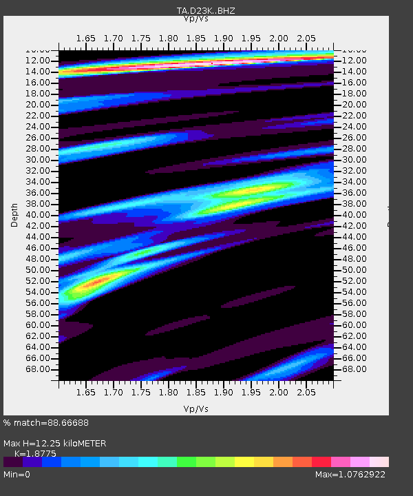
| Estimated Moho Depth: |
12.25 km |
| Estimated Crust Vp/Vs: |
1.88 |
| Assumed Crust Vp: |
6.221 km/s |
| Estimated Crust Vs: |
3.313 km/s |
| Estimated Crust Poisson's Ratio: |
0.30 |
|
| Radial Match: |
88.66688 % |
| Radial Bump: |
385 |
| Transverse Match: |
78.90287 % |
| Transverse Bump: |
400 |
| SOD ConfigId: |
13570011 |
| Insert Time: |
2019-04-29 03:43:30.998 +0000 |
| GWidth: |
2.5 |
| Max Bumps: |
400 |
| Tol: |
0.001 |
|
Signal To Noise
| Channel | StoN | STA | LTA |
| TA:D23K: :BHZ:20171107T21:38:32.775017Z | 12.388439 | 5.83654E-6 | 4.7112792E-7 |
| TA:D23K: :BHN:20171107T21:38:32.775017Z | 1.8019103 | 8.870248E-7 | 4.922691E-7 |
| TA:D23K: :BHE:20171107T21:38:32.775017Z | 3.5292919 | 1.3091664E-6 | 3.7094307E-7 |
| Arrivals |
| Ps | 1.8 SECOND |
| PpPs | 5.5 SECOND |
| PsPs/PpSs | 7.3 SECOND |


