You are here: Home > Network List > TA - USArray Transportable Network (new EarthScope stations) Stations List
> Station F18A Big Timber, MT, USA > Earthquake Result Viewer
F18A Big Timber, MT, USA - Earthquake Result Viewer
| Earthquake location: |
Tonga Islands |
| Earthquake latitude/longitude: |
-21.9/-173.8 |
| Earthquake time(UTC): |
2008/10/19 (293) 05:10:33 GMT |
| Earthquake Depth: |
29 km |
| Earthquake Magnitude: |
6.8 MB, 7.0 MS, 6.9 MW, 6.9 MW |
| Earthquake Catalog/Contributor: |
WHDF/NEIC |
|
| Network: |
TA USArray Transportable Network (new EarthScope stations) |
| Station: |
F18A Big Timber, MT, USA |
| Lat/Lon: |
45.90 N/109.72 W |
| Elevation: |
1291 m |
|
| Distance: |
89.0 deg |
| Az: |
38.921 deg |
| Baz: |
236.699 deg |
| Ray Param: |
0.042169694 |
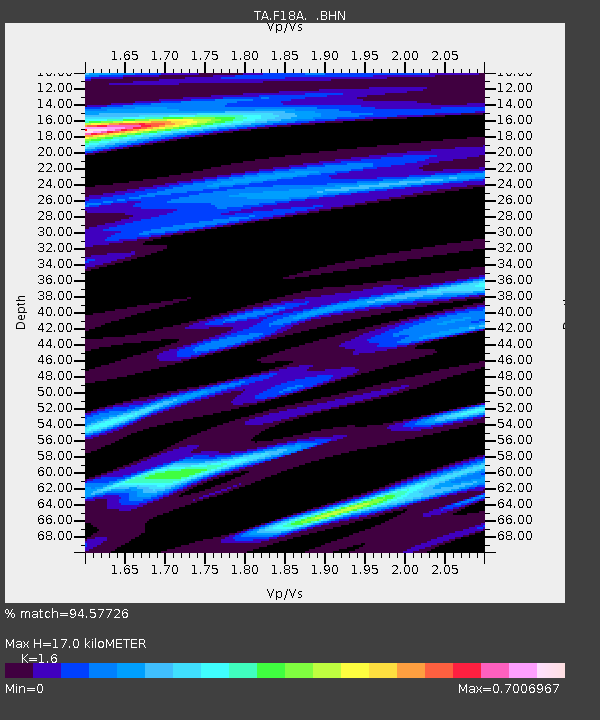
| Estimated Moho Depth: |
17.0 km |
| Estimated Crust Vp/Vs: |
1.60 |
| Assumed Crust Vp: |
6.242 km/s |
| Estimated Crust Vs: |
3.901 km/s |
| Estimated Crust Poisson's Ratio: |
0.18 |
|
| Radial Match: |
94.57726 % |
| Radial Bump: |
341 |
| Transverse Match: |
82.168144 % |
| Transverse Bump: |
341 |
| SOD ConfigId: |
2556 |
| Insert Time: |
2010-03-06 06:07:24.773 +0000 |
| GWidth: |
2.5 |
| Max Bumps: |
400 |
| Tol: |
0.001 |
|

Signal To Noise
| Channel | StoN | STA | LTA |
| TA:F18A: :BHN:20081019T05:22:54.375027Z | 30.049425 | 5.4442135E-6 | 1.811753E-7 |
| TA:F18A: :BHE:20081019T05:22:54.375027Z | 5.7891464 | 1.0926876E-6 | 1.8874763E-7 |
| TA:F18A: :BHZ:20081019T05:22:54.375027Z | 6.859672 | 1.2781773E-6 | 1.8633213E-7 |
| Arrivals |
| Ps | 1.7 SECOND |
| PpPs | 6.9 SECOND |
| PsPs/PpSs | 8.6 SECOND |


