You are here: Home > Network List > TA - USArray Transportable Network (new EarthScope stations) Stations List
> Station J25K Salcha River, AK, USA > Earthquake Result Viewer
J25K Salcha River, AK, USA - Earthquake Result Viewer

| Earthquake location: |
New Guinea, Papua New Guinea |
| Earthquake latitude/longitude: |
-4.2/143.5 |
| Earthquake time(UTC): |
2017/11/07 (311) 21:26:38 GMT |
| Earthquake Depth: |
107 km |
| Earthquake Magnitude: |
6.5 mww |
| Earthquake Catalog/Contributor: |
NEIC PDE/us |
|
| Network: |
TA USArray Transportable Network (new EarthScope stations) |
| Station: |
J25K Salcha River, AK, USA |
| Lat/Lon: |
64.61 N/145.37 W |
| Elevation: |
949 m |
|
| Distance: |
85.8 deg |
| Az: |
24.145 deg |
| Baz: |
251.146 deg |
| Ray Param: |
0.044261917 |
| Estimated Moho Depth: |
30.5 km |
| Estimated Crust Vp/Vs: |
1.89 |
| Assumed Crust Vp: |
6.566 km/s |
| Estimated Crust Vs: |
3.474 km/s |
| Estimated Crust Poisson's Ratio: |
0.31 |
|
| Radial Match: |
89.40425 % |
| Radial Bump: |
382 |
| Transverse Match: |
55.423782 % |
| Transverse Bump: |
390 |
| SOD ConfigId: |
13570011 |
| Insert Time: |
2019-04-29 03:44:30.298 +0000 |
| GWidth: |
2.5 |
| Max Bumps: |
400 |
| Tol: |
0.001 |
|
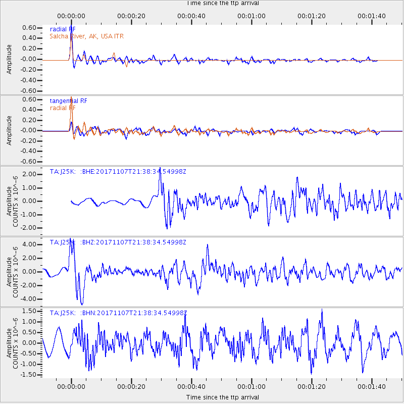
Signal To Noise
| Channel | StoN | STA | LTA |
| TA:J25K: :BHZ:20171107T21:38:34.54998Z | 8.9996395 | 3.164033E-6 | 3.515733E-7 |
| TA:J25K: :BHN:20171107T21:38:34.54998Z | 1.6678991 | 5.3211363E-7 | 3.1903224E-7 |
| TA:J25K: :BHE:20171107T21:38:34.54998Z | 7.5588465 | 1.2525065E-6 | 1.6570075E-7 |
| Arrivals |
| Ps | 4.2 SECOND |
| PpPs | 13 SECOND |
| PsPs/PpSs | 17 SECOND |


