You are here: Home > Network List > TA - USArray Transportable Network (new EarthScope stations) Stations List
> Station M19K Big River Lodge, Big River, AK, USA > Earthquake Result Viewer
M19K Big River Lodge, Big River, AK, USA - Earthquake Result Viewer
| Earthquake location: |
New Guinea, Papua New Guinea |
| Earthquake latitude/longitude: |
-4.2/143.5 |
| Earthquake time(UTC): |
2017/11/07 (311) 21:26:38 GMT |
| Earthquake Depth: |
107 km |
| Earthquake Magnitude: |
6.5 mww |
| Earthquake Catalog/Contributor: |
NEIC PDE/us |
|
| Network: |
TA USArray Transportable Network (new EarthScope stations) |
| Station: |
M19K Big River Lodge, Big River, AK, USA |
| Lat/Lon: |
61.90 N/154.39 W |
| Elevation: |
521 m |
|
| Distance: |
81.0 deg |
| Az: |
25.069 deg |
| Baz: |
243.2 deg |
| Ray Param: |
0.047642097 |
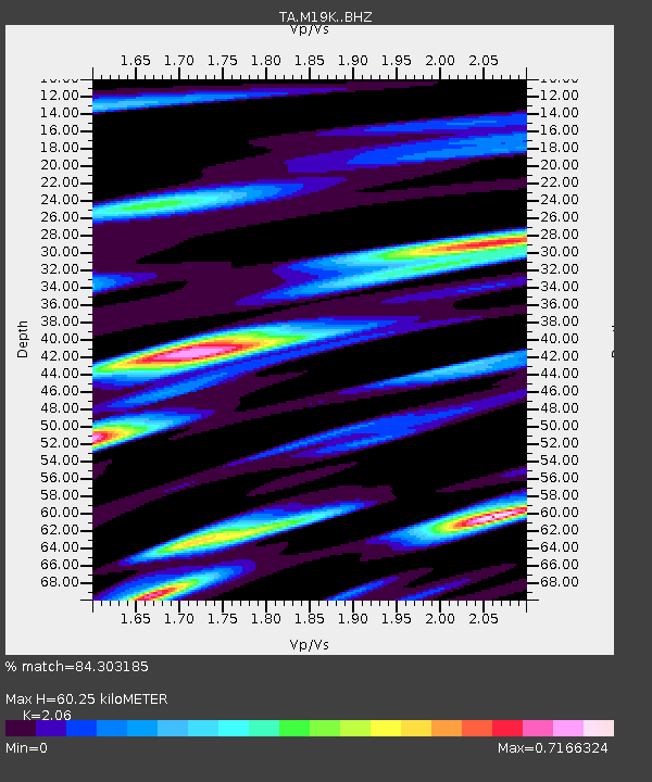
| Estimated Moho Depth: |
60.25 km |
| Estimated Crust Vp/Vs: |
2.06 |
| Assumed Crust Vp: |
6.566 km/s |
| Estimated Crust Vs: |
3.187 km/s |
| Estimated Crust Poisson's Ratio: |
0.35 |
|
| Radial Match: |
84.303185 % |
| Radial Bump: |
400 |
| Transverse Match: |
75.08902 % |
| Transverse Bump: |
400 |
| SOD ConfigId: |
13570011 |
| Insert Time: |
2019-04-29 03:44:53.110 +0000 |
| GWidth: |
2.5 |
| Max Bumps: |
400 |
| Tol: |
0.001 |
|

Signal To Noise
| Channel | StoN | STA | LTA |
| TA:M19K: :BHZ:20171107T21:38:10.025017Z | 9.716524 | 3.2807045E-6 | 3.3764178E-7 |
| TA:M19K: :BHN:20171107T21:38:10.025017Z | 4.5740128 | 5.9877465E-7 | 1.3090796E-7 |
| TA:M19K: :BHE:20171107T21:38:10.025017Z | 5.463651 | 1.3295793E-6 | 2.4334994E-7 |
| Arrivals |
| Ps | 10.0 SECOND |
| PpPs | 27 SECOND |
| PsPs/PpSs | 37 SECOND |


