You are here: Home > Network List > TA - USArray Transportable Network (new EarthScope stations) Stations List
> Station M29M Somme Creek, YT, CAN > Earthquake Result Viewer
M29M Somme Creek, YT, CAN - Earthquake Result Viewer
| Earthquake location: |
New Guinea, Papua New Guinea |
| Earthquake latitude/longitude: |
-4.2/143.5 |
| Earthquake time(UTC): |
2017/11/07 (311) 21:26:38 GMT |
| Earthquake Depth: |
107 km |
| Earthquake Magnitude: |
6.5 mww |
| Earthquake Catalog/Contributor: |
NEIC PDE/us |
|
| Network: |
TA USArray Transportable Network (new EarthScope stations) |
| Station: |
M29M Somme Creek, YT, CAN |
| Lat/Lon: |
62.44 N/138.46 W |
| Elevation: |
1297 m |
|
| Distance: |
88.2 deg |
| Az: |
27.079 deg |
| Baz: |
257.476 deg |
| Ray Param: |
0.04252602 |
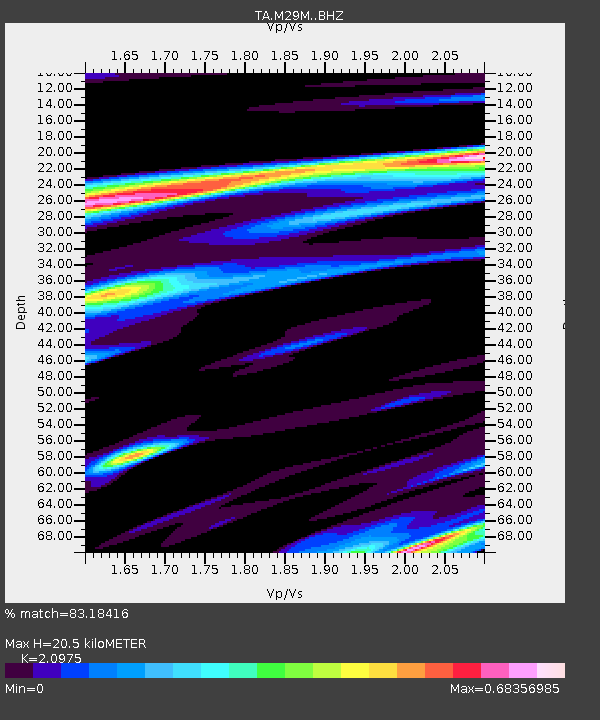
| Estimated Moho Depth: |
20.5 km |
| Estimated Crust Vp/Vs: |
2.10 |
| Assumed Crust Vp: |
6.566 km/s |
| Estimated Crust Vs: |
3.13 km/s |
| Estimated Crust Poisson's Ratio: |
0.35 |
|
| Radial Match: |
83.18416 % |
| Radial Bump: |
357 |
| Transverse Match: |
76.65629 % |
| Transverse Bump: |
400 |
| SOD ConfigId: |
13570011 |
| Insert Time: |
2019-04-29 03:44:59.455 +0000 |
| GWidth: |
2.5 |
| Max Bumps: |
400 |
| Tol: |
0.001 |
|

Signal To Noise
| Channel | StoN | STA | LTA |
| TA:M29M: :BHZ:20171107T21:38:46.04998Z | 5.2910056 | 2.6164737E-6 | 4.945135E-7 |
| TA:M29M: :BHN:20171107T21:38:46.04998Z | 1.8483788 | 8.1506585E-7 | 4.4096257E-7 |
| TA:M29M: :BHE:20171107T21:38:46.04998Z | 2.0809202 | 6.1075053E-7 | 2.9350022E-7 |
| Arrivals |
| Ps | 3.5 SECOND |
| PpPs | 9.5 SECOND |
| PsPs/PpSs | 13 SECOND |


