You are here: Home > Network List > TA - USArray Transportable Network (new EarthScope stations) Stations List
> Station N16K Nishlik Lake, AK, USA > Earthquake Result Viewer
N16K Nishlik Lake, AK, USA - Earthquake Result Viewer
| Earthquake location: |
New Guinea, Papua New Guinea |
| Earthquake latitude/longitude: |
-4.2/143.5 |
| Earthquake time(UTC): |
2017/11/07 (311) 21:26:38 GMT |
| Earthquake Depth: |
107 km |
| Earthquake Magnitude: |
6.5 mww |
| Earthquake Catalog/Contributor: |
NEIC PDE/us |
|
| Network: |
TA USArray Transportable Network (new EarthScope stations) |
| Station: |
N16K Nishlik Lake, AK, USA |
| Lat/Lon: |
60.47 N/158.77 W |
| Elevation: |
582 m |
|
| Distance: |
78.5 deg |
| Az: |
25.312 deg |
| Baz: |
239.413 deg |
| Ray Param: |
0.049378585 |
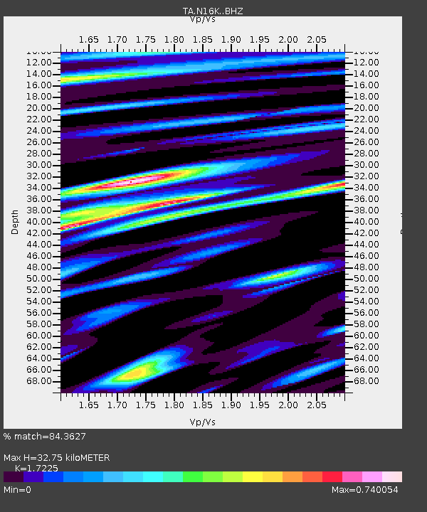
| Estimated Moho Depth: |
32.75 km |
| Estimated Crust Vp/Vs: |
1.72 |
| Assumed Crust Vp: |
6.276 km/s |
| Estimated Crust Vs: |
3.643 km/s |
| Estimated Crust Poisson's Ratio: |
0.25 |
|
| Radial Match: |
84.3627 % |
| Radial Bump: |
400 |
| Transverse Match: |
69.555786 % |
| Transverse Bump: |
400 |
| SOD ConfigId: |
13570011 |
| Insert Time: |
2019-04-29 03:45:02.281 +0000 |
| GWidth: |
2.5 |
| Max Bumps: |
400 |
| Tol: |
0.001 |
|

Signal To Noise
| Channel | StoN | STA | LTA |
| TA:N16K: :BHZ:20171107T21:37:56.325005Z | 8.436457 | 3.673661E-6 | 4.354507E-7 |
| TA:N16K: :BHN:20171107T21:37:56.325005Z | 2.3885374 | 6.8565623E-7 | 2.8706114E-7 |
| TA:N16K: :BHE:20171107T21:37:56.325005Z | 3.4399343 | 1.3504653E-6 | 3.925846E-7 |
| Arrivals |
| Ps | 3.9 SECOND |
| PpPs | 14 SECOND |
| PsPs/PpSs | 18 SECOND |


