You are here: Home > Network List > TA - USArray Transportable Network (new EarthScope stations) Stations List
> Station R17K Ugashik Creek, AK, USA > Earthquake Result Viewer
R17K Ugashik Creek, AK, USA - Earthquake Result Viewer
| Earthquake location: |
New Guinea, Papua New Guinea |
| Earthquake latitude/longitude: |
-4.2/143.5 |
| Earthquake time(UTC): |
2017/11/07 (311) 21:26:38 GMT |
| Earthquake Depth: |
107 km |
| Earthquake Magnitude: |
6.5 mww |
| Earthquake Catalog/Contributor: |
NEIC PDE/us |
|
| Network: |
TA USArray Transportable Network (new EarthScope stations) |
| Station: |
R17K Ugashik Creek, AK, USA |
| Lat/Lon: |
57.64 N/156.39 W |
| Elevation: |
273 m |
|
| Distance: |
78.1 deg |
| Az: |
28.459 deg |
| Baz: |
242.091 deg |
| Ray Param: |
0.049590856 |
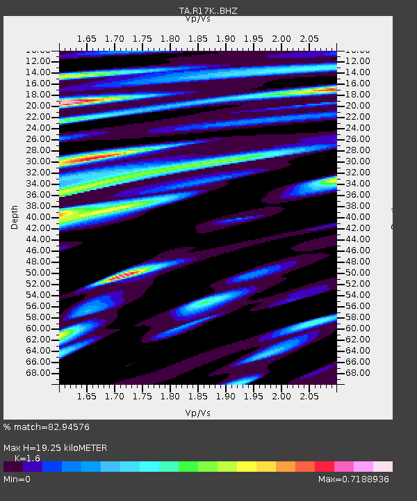
| Estimated Moho Depth: |
19.25 km |
| Estimated Crust Vp/Vs: |
1.60 |
| Assumed Crust Vp: |
6.1 km/s |
| Estimated Crust Vs: |
3.812 km/s |
| Estimated Crust Poisson's Ratio: |
0.18 |
|
| Radial Match: |
82.94576 % |
| Radial Bump: |
400 |
| Transverse Match: |
81.632866 % |
| Transverse Bump: |
400 |
| SOD ConfigId: |
13570011 |
| Insert Time: |
2019-04-29 03:45:30.750 +0000 |
| GWidth: |
2.5 |
| Max Bumps: |
400 |
| Tol: |
0.001 |
|
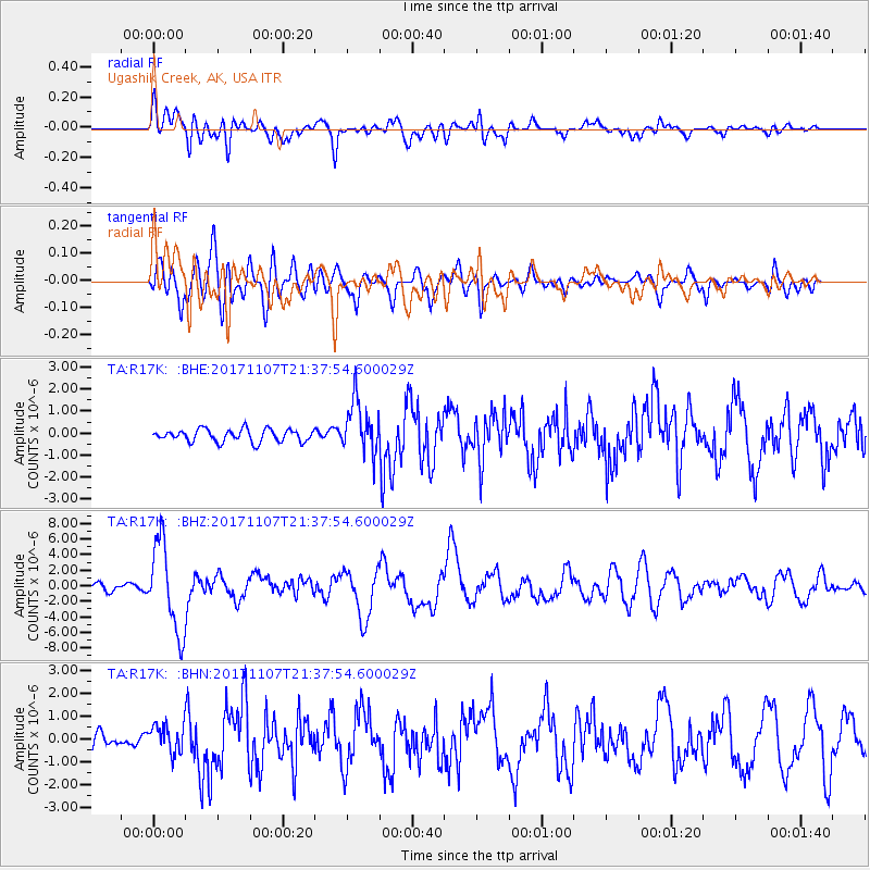
Signal To Noise
| Channel | StoN | STA | LTA |
| TA:R17K: :BHZ:20171107T21:37:54.600029Z | 10.974078 | 5.6969843E-6 | 5.1913105E-7 |
| TA:R17K: :BHN:20171107T21:37:54.600029Z | 1.5397857 | 6.22974E-7 | 4.0458488E-7 |
| TA:R17K: :BHE:20171107T21:37:54.600029Z | 4.1057215 | 1.1693547E-6 | 2.8481102E-7 |
| Arrivals |
| Ps | 2.0 SECOND |
| PpPs | 8.0 SECOND |
| PsPs/PpSs | 9.9 SECOND |


