You are here: Home > Network List > TA - USArray Transportable Network (new EarthScope stations) Stations List
> Station R18K Karluk, AK, USA > Earthquake Result Viewer
R18K Karluk, AK, USA - Earthquake Result Viewer
| Earthquake location: |
New Guinea, Papua New Guinea |
| Earthquake latitude/longitude: |
-4.2/143.5 |
| Earthquake time(UTC): |
2017/11/07 (311) 21:26:38 GMT |
| Earthquake Depth: |
107 km |
| Earthquake Magnitude: |
6.5 mww |
| Earthquake Catalog/Contributor: |
NEIC PDE/us |
|
| Network: |
TA USArray Transportable Network (new EarthScope stations) |
| Station: |
R18K Karluk, AK, USA |
| Lat/Lon: |
57.57 N/154.45 W |
| Elevation: |
39 m |
|
| Distance: |
79.0 deg |
| Az: |
29.009 deg |
| Baz: |
243.83 deg |
| Ray Param: |
0.048985828 |
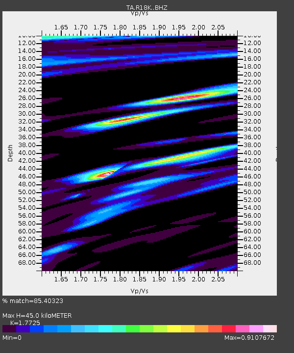
| Estimated Moho Depth: |
45.0 km |
| Estimated Crust Vp/Vs: |
1.77 |
| Assumed Crust Vp: |
6.24 km/s |
| Estimated Crust Vs: |
3.52 km/s |
| Estimated Crust Poisson's Ratio: |
0.27 |
|
| Radial Match: |
85.40323 % |
| Radial Bump: |
400 |
| Transverse Match: |
62.77819 % |
| Transverse Bump: |
400 |
| SOD ConfigId: |
13570011 |
| Insert Time: |
2019-04-29 03:45:31.404 +0000 |
| GWidth: |
2.5 |
| Max Bumps: |
400 |
| Tol: |
0.001 |
|

Signal To Noise
| Channel | StoN | STA | LTA |
| TA:R18K: :BHZ:20171107T21:37:59.475029Z | 9.441382 | 4.851269E-6 | 5.1383034E-7 |
| TA:R18K: :BHN:20171107T21:37:59.475029Z | 4.3279243 | 1.948854E-6 | 4.5029768E-7 |
| TA:R18K: :BHE:20171107T21:37:59.475029Z | 6.6796436 | 3.091816E-6 | 4.628714E-7 |
| Arrivals |
| Ps | 5.7 SECOND |
| PpPs | 19 SECOND |
| PsPs/PpSs | 25 SECOND |


