You are here: Home > Network List > UW - Pacific Northwest Regional Seismic Network Stations List
> Station FISH Seaside, OR, USA > Earthquake Result Viewer
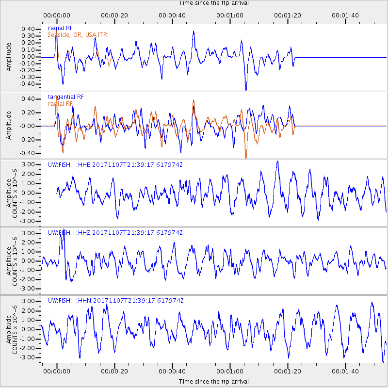
FISH Seaside, OR, USA - Earthquake Result Viewer
*The percent match for this event was below the threshold and hence no stack was calculated.
| Earthquake location: |
New Guinea, Papua New Guinea |
| Earthquake latitude/longitude: |
-4.2/143.5 |
| Earthquake time(UTC): |
2017/11/07 (311) 21:26:38 GMT |
| Earthquake Depth: |
107 km |
| Earthquake Magnitude: |
6.5 mww |
| Earthquake Catalog/Contributor: |
NEIC PDE/us |
|
| Network: |
UW Pacific Northwest Regional Seismic Network |
| Station: |
FISH Seaside, OR, USA |
| Lat/Lon: |
45.93 N/123.56 W |
| Elevation: |
325 m |
|
| Distance: |
95.1 deg |
| Az: |
44.407 deg |
| Baz: |
269.183 deg |
| Ray Param: |
$rayparam |
*The percent match for this event was below the threshold and hence was not used in the summary stack. |
|
| Radial Match: |
49.165108 % |
| Radial Bump: |
376 |
| Transverse Match: |
41.64595 % |
| Transverse Bump: |
400 |
| SOD ConfigId: |
13570011 |
| Insert Time: |
2019-04-29 03:46:01.001 +0000 |
| GWidth: |
2.5 |
| Max Bumps: |
400 |
| Tol: |
0.001 |
|
Signal To Noise
| Channel | StoN | STA | LTA |
| UW:FISH: :HHZ:20171107T21:39:17.617974Z | 2.5264256 | 1.5878995E-6 | 6.2851626E-7 |
| UW:FISH: :HHN:20171107T21:39:17.617974Z | 1.471342 | 9.805854E-7 | 6.6645646E-7 |
| UW:FISH: :HHE:20171107T21:39:17.617974Z | 0.59998184 | 5.2264016E-7 | 8.7109333E-7 |
| Arrivals |
| Ps | |
| PpPs | |
| PsPs/PpSs | |


