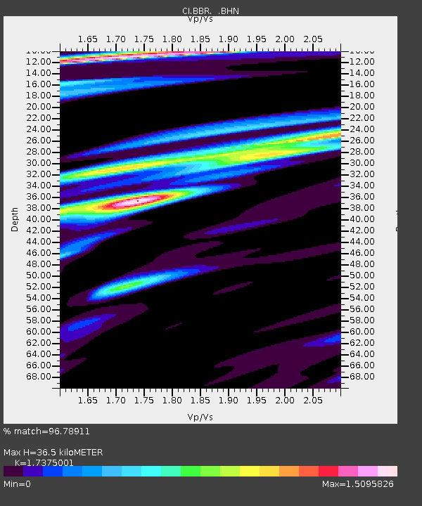
BBR Big Bear Solar Observatory - Earthquake Result Viewer

Earthquake location: Near West Coast Of Colombia
Earthquake latitude/longitude: 4.7/-77.5
Earthquake time(UTC): 2004/11/15 (320) 09:06:56 GMT
Earthquake Depth: 15 km
Earthquake Magnitude: 6.6 MB, 7.1 MS, 7.2 MW, 7.1 MW
Earthquake Catalog/Contributor: WHDF/NEIC
Network: CI Caltech Regional Seismic Network
Station: BBR Big Bear Solar Observatory
Lat/Lon: 34.26 N/116.92 W
Elevation: 2069 m
Distance: 46.9 deg
Az: 313.928 deg
Baz: 119.921 deg
Ray Param: 0.07033741
Estimated Moho Depth: 36.5 km
Estimated Crust Vp/Vs: 1.74
Assumed Crust Vp: 6.276 km/s
Estimated Crust Vs: 3.612 km/s
Estimated Crust Poisson's Ratio: 0.25
Radial Match: 96.78911 %
Radial Bump: 400
Transverse Match: 87.28812 %
Transverse Bump: 400
SOD ConfigId: 2459
Insert Time: 2010-02-26 01:37:00.586 +0000
GWidth: 2.5
Max Bumps: 400
Tol: 0.001

Signal To Noise

ChannelStoNSTALTA
CI:BBR: :BHN:20041115T09:14:55.273013Z8.1085441.0325787E-61.2734452E-7
CI:BBR: :BHE:20041115T09:14:55.273013Z5.94975761.700062E-62.8573632E-7
CI:BBR: :BHZ:20041115T09:14:55.273013Z19.8087714.5029224E-62.2731965E-7
Arrivals
Ps4.6 SECOND
PpPs15 SECOND
PsPs/PpSs20 SECOND