You are here: Home > Network List > TA - USArray Transportable Network (new EarthScope stations) Stations List
> Station F18A Big Timber, MT, USA > Earthquake Result Viewer
F18A Big Timber, MT, USA - Earthquake Result Viewer

| Earthquake location: |
Southern Peru |
| Earthquake latitude/longitude: |
-15.0/-70.4 |
| Earthquake time(UTC): |
2009/07/12 (193) 06:12:47 GMT |
| Earthquake Depth: |
199 km |
| Earthquake Magnitude: |
5.7 MB, 6.1 MW, 6.1 MW |
| Earthquake Catalog/Contributor: |
WHDF/NEIC |
|
| Network: |
TA USArray Transportable Network (new EarthScope stations) |
| Station: |
F18A Big Timber, MT, USA |
| Lat/Lon: |
45.90 N/109.72 W |
| Elevation: |
1291 m |
|
| Distance: |
70.3 deg |
| Az: |
331.993 deg |
| Baz: |
139.478 deg |
| Ray Param: |
0.054541685 |
| Estimated Moho Depth: |
66.25 km |
| Estimated Crust Vp/Vs: |
2.03 |
| Assumed Crust Vp: |
6.242 km/s |
| Estimated Crust Vs: |
3.079 km/s |
| Estimated Crust Poisson's Ratio: |
0.34 |
|
| Radial Match: |
95.12678 % |
| Radial Bump: |
385 |
| Transverse Match: |
87.34271 % |
| Transverse Bump: |
400 |
| SOD ConfigId: |
2648 |
| Insert Time: |
2010-03-06 06:08:17.902 +0000 |
| GWidth: |
2.5 |
| Max Bumps: |
400 |
| Tol: |
0.001 |
|
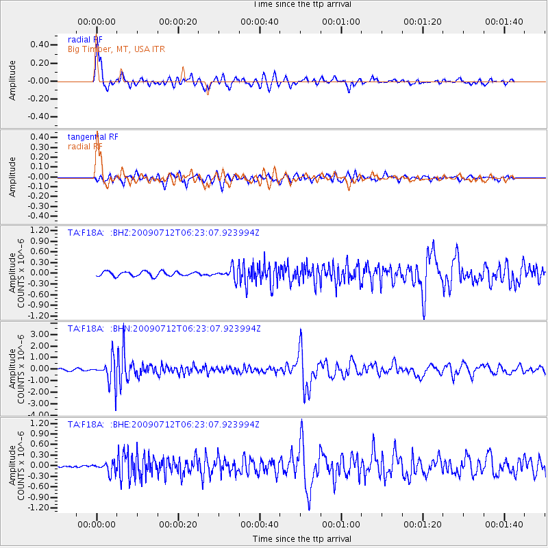
Signal To Noise
| Channel | StoN | STA | LTA |
| TA:F18A: :BHN:20090712T06:23:07.923994Z | 17.115185 | 1.1118634E-6 | 6.496356E-8 |
| TA:F18A: :BHE:20090712T06:23:07.923994Z | 4.5747533 | 1.4601157E-7 | 3.191682E-8 |
| TA:F18A: :BHZ:20090712T06:23:07.923994Z | 2.6292658 | 1.6823235E-7 | 6.398453E-8 |
| Arrivals |
| Ps | 11 SECOND |
| PpPs | 31 SECOND |
| PsPs/PpSs | 42 SECOND |


