You are here: Home > Network List > YT07 - POLENET Stations List
> Station LONW LONW > Earthquake Result Viewer
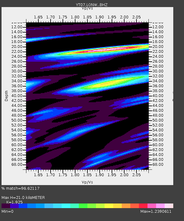
LONW LONW - Earthquake Result Viewer
| Earthquake location: |
New Guinea, Papua New Guinea |
| Earthquake latitude/longitude: |
-4.2/143.5 |
| Earthquake time(UTC): |
2017/11/07 (311) 21:26:38 GMT |
| Earthquake Depth: |
107 km |
| Earthquake Magnitude: |
6.5 mww |
| Earthquake Catalog/Contributor: |
NEIC PDE/us |
|
| Network: |
YT POLENET |
| Station: |
LONW LONW |
| Lat/Lon: |
81.35 S/152.74 E |
| Elevation: |
1548 m |
|
| Distance: |
77.2 deg |
| Az: |
178.569 deg |
| Baz: |
350.533 deg |
| Ray Param: |
0.050229374 |
| Estimated Moho Depth: |
21.0 km |
| Estimated Crust Vp/Vs: |
1.92 |
| Assumed Crust Vp: |
6.306 km/s |
| Estimated Crust Vs: |
3.276 km/s |
| Estimated Crust Poisson's Ratio: |
0.32 |
|
| Radial Match: |
96.62117 % |
| Radial Bump: |
369 |
| Transverse Match: |
85.62082 % |
| Transverse Bump: |
400 |
| SOD ConfigId: |
13570011 |
| Insert Time: |
2019-04-29 03:46:33.180 +0000 |
| GWidth: |
2.5 |
| Max Bumps: |
400 |
| Tol: |
0.001 |
|

Signal To Noise
| Channel | StoN | STA | LTA |
| YT:LONW: :BHZ:20171107T21:37:49.225029Z | 60.52982 | 3.7445363E-6 | 6.186267E-8 |
| YT:LONW: :BHN:20171107T21:37:49.225029Z | 17.706104 | 1.3424287E-6 | 7.581728E-8 |
| YT:LONW: :BHE:20171107T21:37:49.225029Z | 8.869274 | 1.248042E-6 | 1.4071524E-7 |
| Arrivals |
| Ps | 3.2 SECOND |
| PpPs | 9.5 SECOND |
| PsPs/PpSs | 13 SECOND |


