You are here: Home > Network List > US - United States National Seismic Network Stations List
> Station EGMT Eagleton, Montana, USA > Earthquake Result Viewer
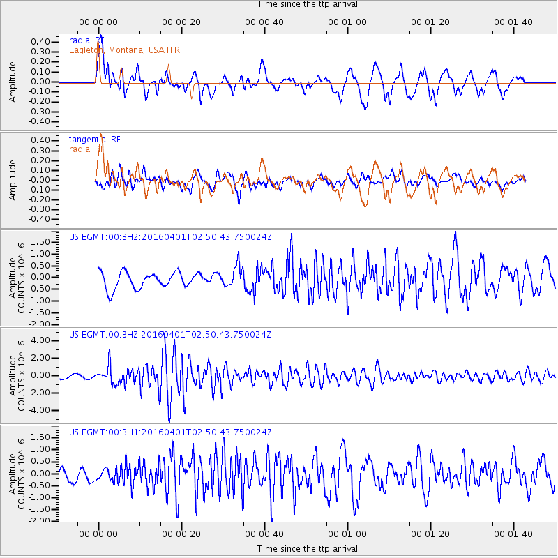
EGMT Eagleton, Montana, USA - Earthquake Result Viewer
*The percent match for this event was below the threshold and hence no stack was calculated.
| Earthquake location: |
Near S. Coast Of Western Honshu |
| Earthquake latitude/longitude: |
33.4/136.4 |
| Earthquake time(UTC): |
2016/04/01 (092) 02:39:07 GMT |
| Earthquake Depth: |
10 km |
| Earthquake Magnitude: |
6.0 MWP |
| Earthquake Catalog/Contributor: |
NEIC PDE/NEIC COMCAT |
|
| Network: |
US United States National Seismic Network |
| Station: |
EGMT Eagleton, Montana, USA |
| Lat/Lon: |
48.02 N/109.75 W |
| Elevation: |
1055 m |
|
| Distance: |
79.7 deg |
| Az: |
38.618 deg |
| Baz: |
308.924 deg |
| Ray Param: |
$rayparam |
*The percent match for this event was below the threshold and hence was not used in the summary stack. |
|
| Radial Match: |
78.332504 % |
| Radial Bump: |
400 |
| Transverse Match: |
76.23998 % |
| Transverse Bump: |
400 |
| SOD ConfigId: |
1475611 |
| Insert Time: |
2016-04-15 03:08:02.555 +0000 |
| GWidth: |
2.5 |
| Max Bumps: |
400 |
| Tol: |
0.001 |
|
Signal To Noise
| Channel | StoN | STA | LTA |
| US:EGMT:00:BHZ:20160401T02:50:43.750024Z | 4.778907 | 9.726507E-7 | 2.0352996E-7 |
| US:EGMT:00:BH1:20160401T02:50:43.750024Z | 0.8313897 | 2.4567524E-7 | 2.954995E-7 |
| US:EGMT:00:BH2:20160401T02:50:43.750024Z | 1.3129383 | 4.450358E-7 | 3.3896168E-7 |
| Arrivals |
| Ps | |
| PpPs | |
| PsPs/PpSs | |


