You are here: Home > Network List > US - United States National Seismic Network Stations List
> Station WMOK Wichita Mountains, Oklahoma, USA > Earthquake Result Viewer
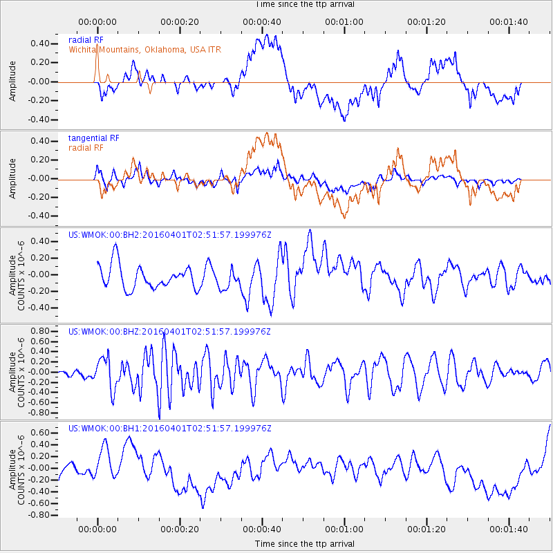
WMOK Wichita Mountains, Oklahoma, USA - Earthquake Result Viewer
*The percent match for this event was below the threshold and hence no stack was calculated.
| Earthquake location: |
Near S. Coast Of Western Honshu |
| Earthquake latitude/longitude: |
33.4/136.4 |
| Earthquake time(UTC): |
2016/04/01 (092) 02:39:07 GMT |
| Earthquake Depth: |
10 km |
| Earthquake Magnitude: |
6.0 MWP |
| Earthquake Catalog/Contributor: |
NEIC PDE/NEIC COMCAT |
|
| Network: |
US United States National Seismic Network |
| Station: |
WMOK Wichita Mountains, Oklahoma, USA |
| Lat/Lon: |
34.74 N/98.78 W |
| Elevation: |
486 m |
|
| Distance: |
94.7 deg |
| Az: |
42.73 deg |
| Baz: |
316.414 deg |
| Ray Param: |
$rayparam |
*The percent match for this event was below the threshold and hence was not used in the summary stack. |
|
| Radial Match: |
25.216915 % |
| Radial Bump: |
400 |
| Transverse Match: |
41.15448 % |
| Transverse Bump: |
400 |
| SOD ConfigId: |
1475611 |
| Insert Time: |
2016-04-15 03:15:55.770 +0000 |
| GWidth: |
2.5 |
| Max Bumps: |
400 |
| Tol: |
0.001 |
|
Signal To Noise
| Channel | StoN | STA | LTA |
| US:WMOK:00:BHZ:20160401T02:51:57.199976Z | 2.1956198 | 3.1857795E-7 | 1.4509705E-7 |
| US:WMOK:00:BH1:20160401T02:51:57.199976Z | 1.1418194 | 2.447805E-7 | 2.1437761E-7 |
| US:WMOK:00:BH2:20160401T02:51:57.199976Z | 0.79098964 | 1.12135666E-7 | 1.417663E-7 |
| Arrivals |
| Ps | |
| PpPs | |
| PsPs/PpSs | |


