You are here: Home > Network List > TA - USArray Transportable Network (new EarthScope stations) Stations List
> Station F18A Big Timber, MT, USA > Earthquake Result Viewer
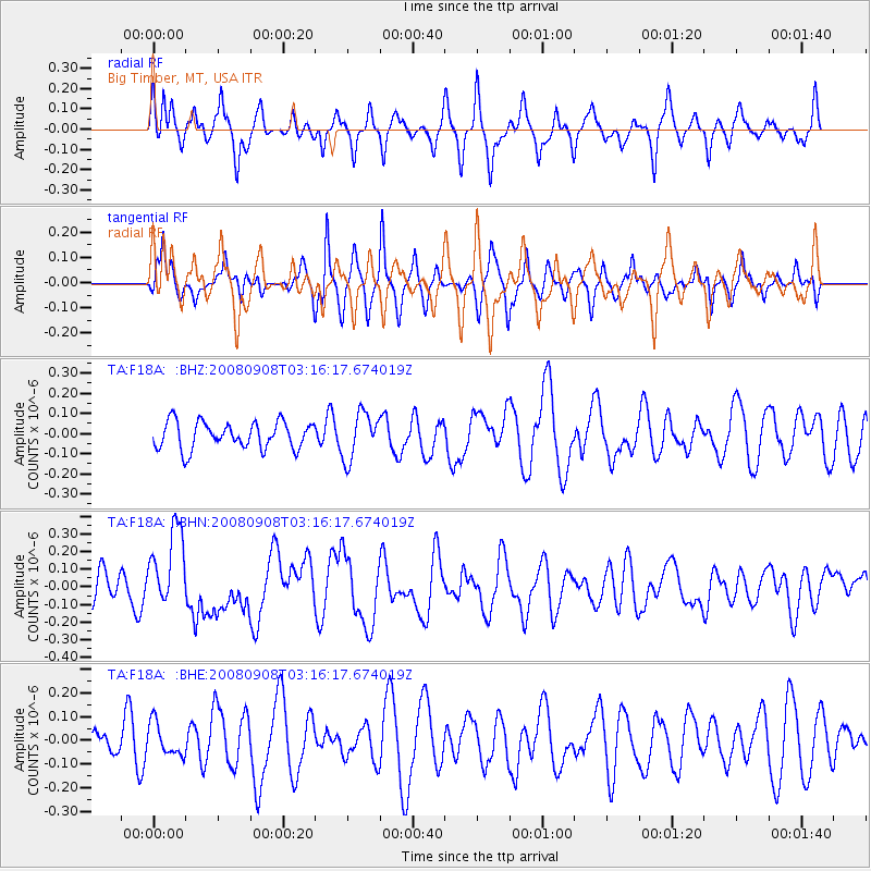
F18A Big Timber, MT, USA - Earthquake Result Viewer
*The percent match for this event was below the threshold and hence no stack was calculated.
| Earthquake location: |
Vanuatu Islands |
| Earthquake latitude/longitude: |
-20.0/169.1 |
| Earthquake time(UTC): |
2008/09/08 (252) 03:03:15 GMT |
| Earthquake Depth: |
36 km |
| Earthquake Magnitude: |
6.0 MB, 5.8 MS, 6.2 MW, 6.2 MW |
| Earthquake Catalog/Contributor: |
WHDF/NEIC |
|
| Network: |
TA USArray Transportable Network (new EarthScope stations) |
| Station: |
F18A Big Timber, MT, USA |
| Lat/Lon: |
45.90 N/109.72 W |
| Elevation: |
1291 m |
|
| Distance: |
98.2 deg |
| Az: |
44.193 deg |
| Baz: |
249.893 deg |
| Ray Param: |
$rayparam |
*The percent match for this event was below the threshold and hence was not used in the summary stack. |
|
| Radial Match: |
62.413486 % |
| Radial Bump: |
393 |
| Transverse Match: |
51.98065 % |
| Transverse Bump: |
331 |
| SOD ConfigId: |
2560 |
| Insert Time: |
2010-03-06 06:09:14.844 +0000 |
| GWidth: |
2.5 |
| Max Bumps: |
400 |
| Tol: |
0.001 |
|
Signal To Noise
| Channel | StoN | STA | LTA |
| TA:F18A: :BHN:20080908T03:16:17.674019Z | 1.8651577 | 2.289333E-7 | 1.2274207E-7 |
| TA:F18A: :BHE:20080908T03:16:17.674019Z | 0.61096966 | 6.88003E-8 | 1.12608376E-7 |
| TA:F18A: :BHZ:20080908T03:16:17.674019Z | 1.7170238 | 1.144083E-7 | 6.663175E-8 |
| Arrivals |
| Ps | |
| PpPs | |
| PsPs/PpSs | |


