You are here: Home > Network List > TA - USArray Transportable Network (new EarthScope stations) Stations List
> Station F18A Big Timber, MT, USA > Earthquake Result Viewer
F18A Big Timber, MT, USA - Earthquake Result Viewer
*The percent match for this event was below the threshold and hence no stack was calculated.
| Earthquake location: |
Colombia |
| Earthquake latitude/longitude: |
4.8/-75.5 |
| Earthquake time(UTC): |
2008/09/13 (257) 09:32:01 GMT |
| Earthquake Depth: |
133 km |
| Earthquake Magnitude: |
5.9 MB, 5.7 MW, 5.7 MW |
| Earthquake Catalog/Contributor: |
WHDF/NEIC |
|
| Network: |
TA USArray Transportable Network (new EarthScope stations) |
| Station: |
F18A Big Timber, MT, USA |
| Lat/Lon: |
45.90 N/109.72 W |
| Elevation: |
1291 m |
|
| Distance: |
50.6 deg |
| Az: |
329.469 deg |
| Baz: |
133.53 deg |
| Ray Param: |
$rayparam |
*The percent match for this event was below the threshold and hence was not used in the summary stack. |
|
| Radial Match: |
78.1777 % |
| Radial Bump: |
400 |
| Transverse Match: |
65.26329 % |
| Transverse Bump: |
400 |
| SOD ConfigId: |
2560 |
| Insert Time: |
2010-03-06 06:09:18.394 +0000 |
| GWidth: |
2.5 |
| Max Bumps: |
400 |
| Tol: |
0.001 |
|
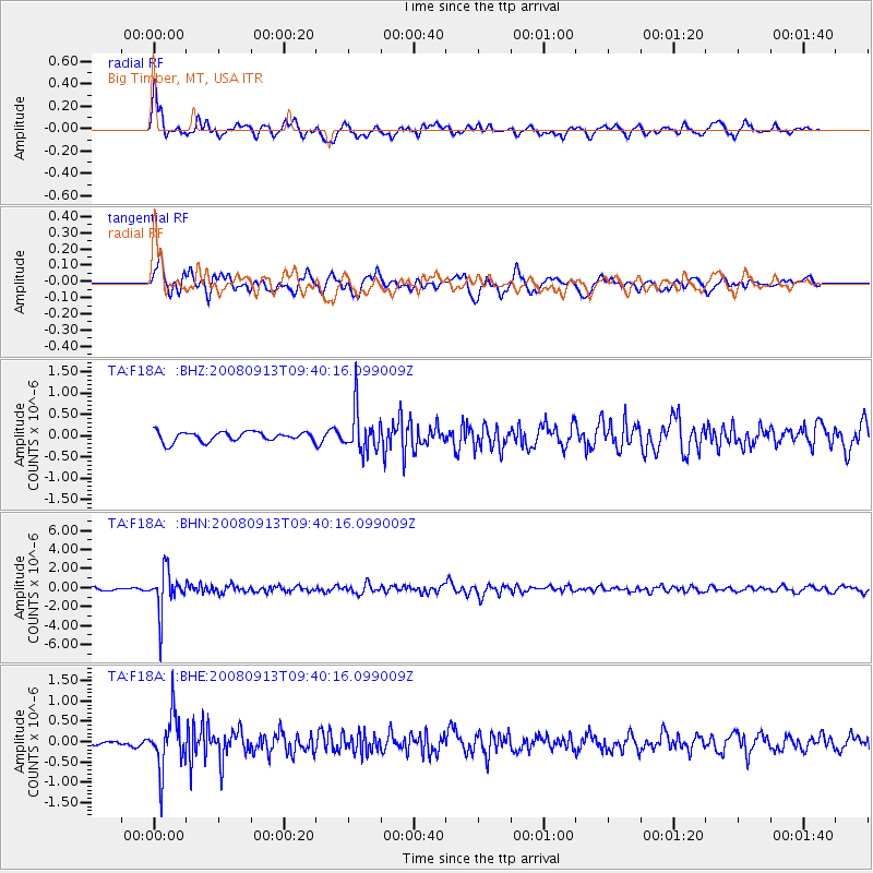
Signal To Noise
| Channel | StoN | STA | LTA |
| TA:F18A: :BHN:20080913T09:40:16.099009Z | 17.44554 | 2.1534136E-6 | 1.2343634E-7 |
| TA:F18A: :BHE:20080913T09:40:16.099009Z | 9.502934 | 6.5946637E-7 | 6.939607E-8 |
| TA:F18A: :BHZ:20080913T09:40:16.099009Z | 4.375375 | 4.949117E-7 | 1.13112996E-7 |
| Arrivals |
| Ps | |
| PpPs | |
| PsPs/PpSs | |


