You are here: Home > Network List > TA - USArray Transportable Network (new EarthScope stations) Stations List
> Station R32K Eaglecrest, AK, USA > Earthquake Result Viewer
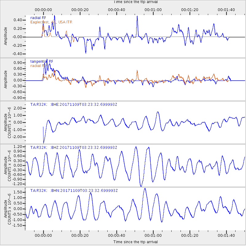
R32K Eaglecrest, AK, USA - Earthquake Result Viewer
*The percent match for this event was below the threshold and hence no stack was calculated.
| Earthquake location: |
Halmahera, Indonesia |
| Earthquake latitude/longitude: |
1.9/127.1 |
| Earthquake time(UTC): |
2017/11/09 (313) 03:11:02 GMT |
| Earthquake Depth: |
99 km |
| Earthquake Magnitude: |
5.2 Mww |
| Earthquake Catalog/Contributor: |
NEIC PDE/us |
|
| Network: |
TA USArray Transportable Network (new EarthScope stations) |
| Station: |
R32K Eaglecrest, AK, USA |
| Lat/Lon: |
58.27 N/134.52 W |
| Elevation: |
386 m |
|
| Distance: |
92.8 deg |
| Az: |
31.56 deg |
| Baz: |
278.123 deg |
| Ray Param: |
$rayparam |
*The percent match for this event was below the threshold and hence was not used in the summary stack. |
|
| Radial Match: |
38.363747 % |
| Radial Bump: |
400 |
| Transverse Match: |
60.0781 % |
| Transverse Bump: |
400 |
| SOD ConfigId: |
13570011 |
| Insert Time: |
2019-04-29 03:58:14.964 +0000 |
| GWidth: |
2.5 |
| Max Bumps: |
400 |
| Tol: |
0.001 |
|
Signal To Noise
| Channel | StoN | STA | LTA |
| TA:R32K: :BHZ:20171109T03:23:32.699993Z | 1.7272995 | 5.4518574E-7 | 3.1562894E-7 |
| TA:R32K: :BHN:20171109T03:23:32.699993Z | 0.92054063 | 6.6108265E-7 | 7.1814605E-7 |
| TA:R32K: :BHE:20171109T03:23:32.699993Z | 0.8417283 | 6.024067E-7 | 7.156783E-7 |
| Arrivals |
| Ps | |
| PpPs | |
| PsPs/PpSs | |


