You are here: Home > Network List > UU - University of Utah Regional Network Stations List
> Station KNB Kanab, UT, USA > Earthquake Result Viewer
KNB Kanab, UT, USA - Earthquake Result Viewer
| Earthquake location: |
Near S. Coast Of Western Honshu |
| Earthquake latitude/longitude: |
33.4/136.4 |
| Earthquake time(UTC): |
2016/04/01 (092) 02:39:07 GMT |
| Earthquake Depth: |
10 km |
| Earthquake Magnitude: |
6.0 MWP |
| Earthquake Catalog/Contributor: |
NEIC PDE/NEIC COMCAT |
|
| Network: |
UU University of Utah Regional Network |
| Station: |
KNB Kanab, UT, USA |
| Lat/Lon: |
37.02 N/112.82 W |
| Elevation: |
1715 m |
|
| Distance: |
84.8 deg |
| Az: |
48.721 deg |
| Baz: |
308.216 deg |
| Ray Param: |
0.0452282 |
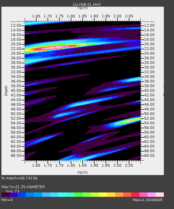
| Estimated Moho Depth: |
21.25 km |
| Estimated Crust Vp/Vs: |
1.73 |
| Assumed Crust Vp: |
6.194 km/s |
| Estimated Crust Vs: |
3.58 km/s |
| Estimated Crust Poisson's Ratio: |
0.25 |
|
| Radial Match: |
86.74156 % |
| Radial Bump: |
356 |
| Transverse Match: |
82.38518 % |
| Transverse Bump: |
325 |
| SOD ConfigId: |
1475611 |
| Insert Time: |
2016-04-15 03:18:56.542 +0000 |
| GWidth: |
2.5 |
| Max Bumps: |
400 |
| Tol: |
0.001 |
|
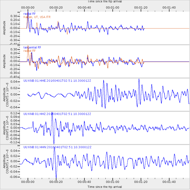
Signal To Noise
| Channel | StoN | STA | LTA |
| UU:KNB:01:HHZ:20160401T02:51:10.300012Z | 2.12722 | 1.7600579E-8 | 8.2739815E-9 |
| UU:KNB:01:HHN:20160401T02:51:10.300012Z | 0.7756815 | 5.142088E-9 | 6.629123E-9 |
| UU:KNB:01:HHE:20160401T02:51:10.300012Z | 1.2245697 | 5.524261E-9 | 4.5111856E-9 |
| Arrivals |
| Ps | 2.6 SECOND |
| PpPs | 9.1 SECOND |
| PsPs/PpSs | 12 SECOND |


