You are here: Home > Network List > KR - Kyrgyz Digital Network Stations List
> Station BOOM Boom, Kyrgyzstan > Earthquake Result Viewer
BOOM Boom, Kyrgyzstan - Earthquake Result Viewer
| Earthquake location: |
Southeast Of Honshu, Japan |
| Earthquake latitude/longitude: |
32.5/141.4 |
| Earthquake time(UTC): |
2017/11/09 (313) 07:42:12 GMT |
| Earthquake Depth: |
20 km |
| Earthquake Magnitude: |
6.0 Mww |
| Earthquake Catalog/Contributor: |
NEIC PDE/us |
|
| Network: |
KR Kyrgyz Digital Network |
| Station: |
BOOM Boom, Kyrgyzstan |
| Lat/Lon: |
42.49 N/75.94 E |
| Elevation: |
1737 m |
|
| Distance: |
51.7 deg |
| Az: |
300.994 deg |
| Baz: |
78.226 deg |
| Ray Param: |
0.06719021 |
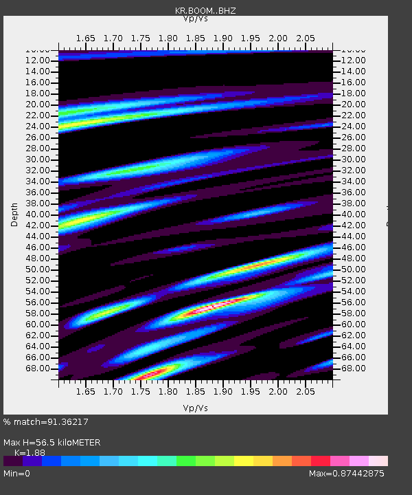
| Estimated Moho Depth: |
56.5 km |
| Estimated Crust Vp/Vs: |
1.88 |
| Assumed Crust Vp: |
6.306 km/s |
| Estimated Crust Vs: |
3.354 km/s |
| Estimated Crust Poisson's Ratio: |
0.30 |
|
| Radial Match: |
91.36217 % |
| Radial Bump: |
385 |
| Transverse Match: |
68.519196 % |
| Transverse Bump: |
400 |
| SOD ConfigId: |
13570011 |
| Insert Time: |
2019-04-29 04:01:58.563 +0000 |
| GWidth: |
2.5 |
| Max Bumps: |
400 |
| Tol: |
0.001 |
|

Signal To Noise
| Channel | StoN | STA | LTA |
| KR:BOOM: :BHZ:20171109T07:50:47.159995Z | 5.223471 | 6.489578E-7 | 1.242388E-7 |
| KR:BOOM: :BHN:20171109T07:50:47.159995Z | 1.5905826 | 1.9948921E-7 | 1.2541895E-7 |
| KR:BOOM: :BHE:20171109T07:50:47.159995Z | 4.542143 | 3.381546E-7 | 7.4448245E-8 |
| Arrivals |
| Ps | 8.3 SECOND |
| PpPs | 25 SECOND |
| PsPs/PpSs | 33 SECOND |


