You are here: Home > Network List > TA - USArray Transportable Network (new EarthScope stations) Stations List
> Station F18A Big Timber, MT, USA > Earthquake Result Viewer
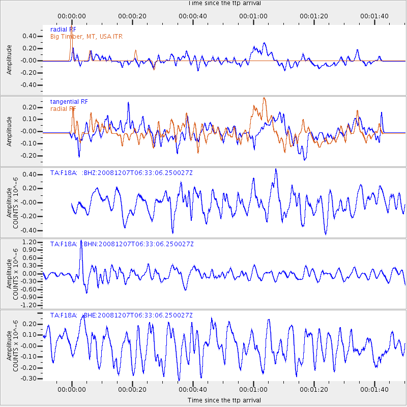
F18A Big Timber, MT, USA - Earthquake Result Viewer
*The percent match for this event was below the threshold and hence no stack was calculated.
| Earthquake location: |
Northern Mid-Atlantic Ridge |
| Earthquake latitude/longitude: |
13.4/-44.8 |
| Earthquake time(UTC): |
2008/12/07 (342) 06:23:09 GMT |
| Earthquake Depth: |
10 km |
| Earthquake Magnitude: |
5.6 MB, 5.3 MS, 5.7 MW |
| Earthquake Catalog/Contributor: |
WHDF/NEIC |
|
| Network: |
TA USArray Transportable Network (new EarthScope stations) |
| Station: |
F18A Big Timber, MT, USA |
| Lat/Lon: |
45.90 N/109.72 W |
| Elevation: |
1291 m |
|
| Distance: |
63.1 deg |
| Az: |
314.841 deg |
| Baz: |
98.738 deg |
| Ray Param: |
$rayparam |
*The percent match for this event was below the threshold and hence was not used in the summary stack. |
|
| Radial Match: |
38.350685 % |
| Radial Bump: |
400 |
| Transverse Match: |
52.010612 % |
| Transverse Bump: |
400 |
| SOD ConfigId: |
2658 |
| Insert Time: |
2010-03-06 06:10:00.418 +0000 |
| GWidth: |
2.5 |
| Max Bumps: |
400 |
| Tol: |
0.001 |
|
Signal To Noise
| Channel | StoN | STA | LTA |
| TA:F18A: :BHN:20081207T06:33:06.250027Z | 3.3075159 | 4.6966426E-7 | 1.419991E-7 |
| TA:F18A: :BHE:20081207T06:33:06.250027Z | 1.2334398 | 1.6485929E-7 | 1.3365816E-7 |
| TA:F18A: :BHZ:20081207T06:33:06.250027Z | 1.2414619 | 1.6271835E-7 | 1.3106995E-7 |
| Arrivals |
| Ps | |
| PpPs | |
| PsPs/PpSs | |


