You are here: Home > Network List > TA - USArray Transportable Network (new EarthScope stations) Stations List
> Station G23K Bananza Creek, AK, USA > Earthquake Result Viewer
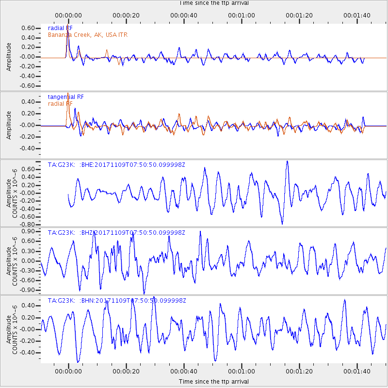
G23K Bananza Creek, AK, USA - Earthquake Result Viewer
*The percent match for this event was below the threshold and hence no stack was calculated.
| Earthquake location: |
Southeast Of Honshu, Japan |
| Earthquake latitude/longitude: |
32.5/141.4 |
| Earthquake time(UTC): |
2017/11/09 (313) 07:42:12 GMT |
| Earthquake Depth: |
20 km |
| Earthquake Magnitude: |
6.0 Mww |
| Earthquake Catalog/Contributor: |
NEIC PDE/us |
|
| Network: |
TA USArray Transportable Network (new EarthScope stations) |
| Station: |
G23K Bananza Creek, AK, USA |
| Lat/Lon: |
66.71 N/150.02 W |
| Elevation: |
746 m |
|
| Distance: |
52.1 deg |
| Az: |
27.958 deg |
| Baz: |
264.849 deg |
| Ray Param: |
$rayparam |
*The percent match for this event was below the threshold and hence was not used in the summary stack. |
|
| Radial Match: |
75.071205 % |
| Radial Bump: |
400 |
| Transverse Match: |
64.84216 % |
| Transverse Bump: |
400 |
| SOD ConfigId: |
13570011 |
| Insert Time: |
2019-04-29 04:04:22.108 +0000 |
| GWidth: |
2.5 |
| Max Bumps: |
400 |
| Tol: |
0.001 |
|
Signal To Noise
| Channel | StoN | STA | LTA |
| TA:G23K: :BHZ:20171109T07:50:50.099998Z | 2.2749465 | 4.4249276E-7 | 1.9450688E-7 |
| TA:G23K: :BHN:20171109T07:50:50.099998Z | 1.9284341 | 3.1593657E-7 | 1.6383063E-7 |
| TA:G23K: :BHE:20171109T07:50:50.099998Z | 1.805952 | 2.6149485E-7 | 1.4479613E-7 |
| Arrivals |
| Ps | |
| PpPs | |
| PsPs/PpSs | |


