You are here: Home > Network List > TA - USArray Transportable Network (new EarthScope stations) Stations List
> Station R31K City Hall, Gustavus, AK, USA > Earthquake Result Viewer
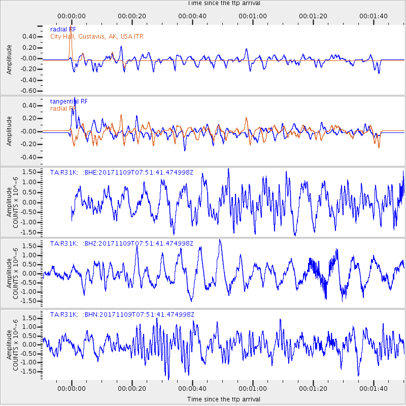
R31K City Hall, Gustavus, AK, USA - Earthquake Result Viewer
*The percent match for this event was below the threshold and hence no stack was calculated.
| Earthquake location: |
Southeast Of Honshu, Japan |
| Earthquake latitude/longitude: |
32.5/141.4 |
| Earthquake time(UTC): |
2017/11/09 (313) 07:42:12 GMT |
| Earthquake Depth: |
20 km |
| Earthquake Magnitude: |
6.0 Mww |
| Earthquake Catalog/Contributor: |
NEIC PDE/us |
|
| Network: |
TA USArray Transportable Network (new EarthScope stations) |
| Station: |
R31K City Hall, Gustavus, AK, USA |
| Lat/Lon: |
58.41 N/135.74 W |
| Elevation: |
15 m |
|
| Distance: |
59.3 deg |
| Az: |
37.402 deg |
| Baz: |
282.896 deg |
| Ray Param: |
$rayparam |
*The percent match for this event was below the threshold and hence was not used in the summary stack. |
|
| Radial Match: |
52.15351 % |
| Radial Bump: |
400 |
| Transverse Match: |
77.934975 % |
| Transverse Bump: |
400 |
| SOD ConfigId: |
13570011 |
| Insert Time: |
2019-04-29 04:04:52.150 +0000 |
| GWidth: |
2.5 |
| Max Bumps: |
400 |
| Tol: |
0.001 |
|
Signal To Noise
| Channel | StoN | STA | LTA |
| TA:R31K: :BHZ:20171109T07:51:41.474998Z | 0.90593755 | 4.228419E-7 | 4.667451E-7 |
| TA:R31K: :BHN:20171109T07:51:41.474998Z | 0.97563803 | 3.3083273E-7 | 3.3909373E-7 |
| TA:R31K: :BHE:20171109T07:51:41.474998Z | 1.9731297 | 8.597064E-7 | 4.3570697E-7 |
| Arrivals |
| Ps | |
| PpPs | |
| PsPs/PpSs | |


