You are here: Home > Network List > TA - USArray Transportable Network (new EarthScope stations) Stations List
> Station F18A Big Timber, MT, USA > Earthquake Result Viewer
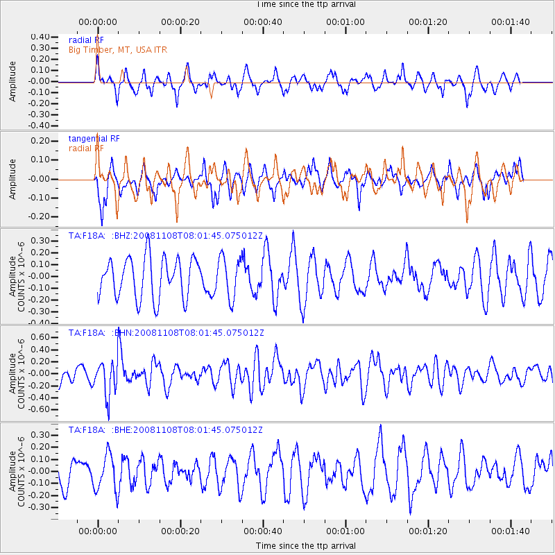
F18A Big Timber, MT, USA - Earthquake Result Viewer
*The percent match for this event was below the threshold and hence no stack was calculated.
| Earthquake location: |
Tonga Islands |
| Earthquake latitude/longitude: |
-15.2/-174.2 |
| Earthquake time(UTC): |
2008/11/08 (313) 07:49:59 GMT |
| Earthquake Depth: |
121 km |
| Earthquake Magnitude: |
6.0 MW, 5.4 MB, 6.0 MW |
| Earthquake Catalog/Contributor: |
WHDF/NEIC |
|
| Network: |
TA USArray Transportable Network (new EarthScope stations) |
| Station: |
F18A Big Timber, MT, USA |
| Lat/Lon: |
45.90 N/109.72 W |
| Elevation: |
1291 m |
|
| Distance: |
84.1 deg |
| Az: |
39.325 deg |
| Baz: |
241.177 deg |
| Ray Param: |
$rayparam |
*The percent match for this event was below the threshold and hence was not used in the summary stack. |
|
| Radial Match: |
57.739346 % |
| Radial Bump: |
358 |
| Transverse Match: |
50.257236 % |
| Transverse Bump: |
376 |
| SOD ConfigId: |
2658 |
| Insert Time: |
2010-03-06 06:10:29.170 +0000 |
| GWidth: |
2.5 |
| Max Bumps: |
400 |
| Tol: |
0.001 |
|
Signal To Noise
| Channel | StoN | STA | LTA |
| TA:F18A: :BHN:20081108T08:01:45.075012Z | 2.0173013 | 2.8516135E-7 | 1.4135784E-7 |
| TA:F18A: :BHE:20081108T08:01:45.075012Z | 1.1904268 | 1.561318E-7 | 1.3115617E-7 |
| TA:F18A: :BHZ:20081108T08:01:45.075012Z | 1.0270885 | 1.7560512E-7 | 1.7097369E-7 |
| Arrivals |
| Ps | |
| PpPs | |
| PsPs/PpSs | |


