You are here: Home > Network List > WY - Yellowstone Wyoming Seismic Network Stations List
> Station YHH Holmes Hill, YNP, WY, USA > Earthquake Result Viewer
YHH Holmes Hill, YNP, WY, USA - Earthquake Result Viewer
| Earthquake location: |
Near S. Coast Of Western Honshu |
| Earthquake latitude/longitude: |
33.4/136.4 |
| Earthquake time(UTC): |
2016/04/01 (092) 02:39:07 GMT |
| Earthquake Depth: |
10 km |
| Earthquake Magnitude: |
6.0 MWP |
| Earthquake Catalog/Contributor: |
NEIC PDE/NEIC COMCAT |
|
| Network: |
WY Yellowstone Wyoming Seismic Network |
| Station: |
YHH Holmes Hill, YNP, WY, USA |
| Lat/Lon: |
44.79 N/110.85 W |
| Elevation: |
2717 m |
|
| Distance: |
81.1 deg |
| Az: |
41.658 deg |
| Baz: |
308.639 deg |
| Ray Param: |
0.047799923 |
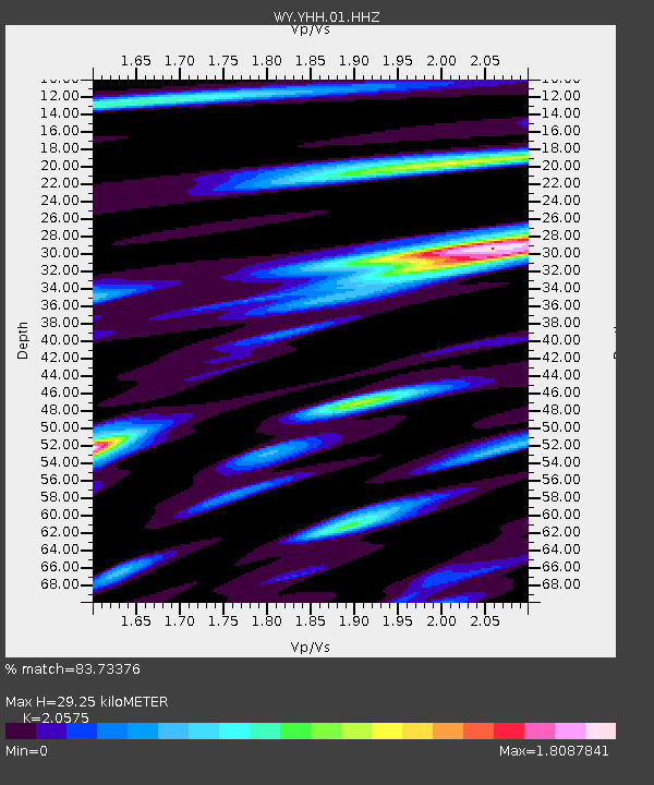
| Estimated Moho Depth: |
29.25 km |
| Estimated Crust Vp/Vs: |
2.06 |
| Assumed Crust Vp: |
6.35 km/s |
| Estimated Crust Vs: |
3.086 km/s |
| Estimated Crust Poisson's Ratio: |
0.35 |
|
| Radial Match: |
83.73376 % |
| Radial Bump: |
334 |
| Transverse Match: |
66.693344 % |
| Transverse Bump: |
387 |
| SOD ConfigId: |
1475611 |
| Insert Time: |
2016-04-15 03:25:01.423 +0000 |
| GWidth: |
2.5 |
| Max Bumps: |
400 |
| Tol: |
0.001 |
|

Signal To Noise
| Channel | StoN | STA | LTA |
| WY:YHH:01:HHZ:20160401T02:50:51.428003Z | 3.063725 | 9.988989E-9 | 3.2604068E-9 |
| WY:YHH:01:HHN:20160401T02:50:51.428003Z | 1.8658204 | 4.9986406E-9 | 2.6790579E-9 |
| WY:YHH:01:HHE:20160401T02:50:51.428003Z | 0.6595918 | 3.7445718E-9 | 5.677105E-9 |
| Arrivals |
| Ps | 5.0 SECOND |
| PpPs | 14 SECOND |
| PsPs/PpSs | 19 SECOND |


