You are here: Home > Network List > WY - Yellowstone Wyoming Seismic Network Stations List
> Station YNR Norris Junction, YNP, WY, USA > Earthquake Result Viewer
YNR Norris Junction, YNP, WY, USA - Earthquake Result Viewer

| Earthquake location: |
Near S. Coast Of Western Honshu |
| Earthquake latitude/longitude: |
33.4/136.4 |
| Earthquake time(UTC): |
2016/04/01 (092) 02:39:07 GMT |
| Earthquake Depth: |
10 km |
| Earthquake Magnitude: |
6.0 MWP |
| Earthquake Catalog/Contributor: |
NEIC PDE/NEIC COMCAT |
|
| Network: |
WY Yellowstone Wyoming Seismic Network |
| Station: |
YNR Norris Junction, YNP, WY, USA |
| Lat/Lon: |
44.72 N/110.68 W |
| Elevation: |
2336 m |
|
| Distance: |
81.3 deg |
| Az: |
41.638 deg |
| Baz: |
308.756 deg |
| Ray Param: |
0.047700968 |
| Estimated Moho Depth: |
20.25 km |
| Estimated Crust Vp/Vs: |
1.99 |
| Assumed Crust Vp: |
6.35 km/s |
| Estimated Crust Vs: |
3.187 km/s |
| Estimated Crust Poisson's Ratio: |
0.33 |
|
| Radial Match: |
80.46856 % |
| Radial Bump: |
361 |
| Transverse Match: |
66.028946 % |
| Transverse Bump: |
399 |
| SOD ConfigId: |
1475611 |
| Insert Time: |
2016-04-15 03:25:23.147 +0000 |
| GWidth: |
2.5 |
| Max Bumps: |
400 |
| Tol: |
0.001 |
|
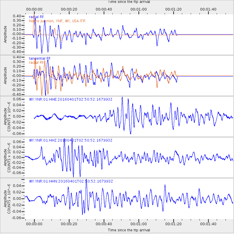
Signal To Noise
| Channel | StoN | STA | LTA |
| WY:YNR:01:HHZ:20160401T02:50:52.167993Z | 3.5245461 | 1.4971123E-8 | 4.247674E-9 |
| WY:YNR:01:HHN:20160401T02:50:52.167993Z | 1.2612798 | 5.656084E-9 | 4.484401E-9 |
| WY:YNR:01:HHE:20160401T02:50:52.167993Z | 0.6760233 | 3.307692E-9 | 4.8928666E-9 |
| Arrivals |
| Ps | 3.2 SECOND |
| PpPs | 9.3 SECOND |
| PsPs/PpSs | 13 SECOND |


