You are here: Home > Network List > IC - New China Digital Seismograph Network Stations List
> Station KMI Kunming, Yunnan Province, China > Earthquake Result Viewer
KMI Kunming, Yunnan Province, China - Earthquake Result Viewer
*The percent match for this event was below the threshold and hence no stack was calculated.
| Earthquake location: |
Banda Sea |
| Earthquake latitude/longitude: |
-5.6/129.5 |
| Earthquake time(UTC): |
2016/03/19 (079) 08:51:24 GMT |
| Earthquake Depth: |
270 km |
| Earthquake Magnitude: |
5.7 MWW |
| Earthquake Catalog/Contributor: |
NEIC PDE/NEIC COMCAT |
|
| Network: |
IC New China Digital Seismograph Network |
| Station: |
KMI Kunming, Yunnan Province, China |
| Lat/Lon: |
25.12 N/102.74 E |
| Elevation: |
1975 m |
|
| Distance: |
40.1 deg |
| Az: |
320.689 deg |
| Baz: |
135.923 deg |
| Ray Param: |
$rayparam |
*The percent match for this event was below the threshold and hence was not used in the summary stack. |
|
| Radial Match: |
68.54391 % |
| Radial Bump: |
400 |
| Transverse Match: |
51.15242 % |
| Transverse Bump: |
400 |
| SOD ConfigId: |
1475611 |
| Insert Time: |
2016-04-15 12:45:50.755 +0000 |
| GWidth: |
2.5 |
| Max Bumps: |
400 |
| Tol: |
0.001 |
|
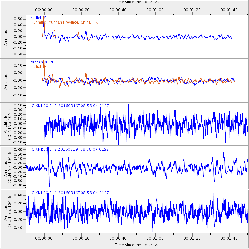
Signal To Noise
| Channel | StoN | STA | LTA |
| IC:KMI:00:BHZ:20160319T08:58:04.019Z | 4.585521 | 3.7826666E-7 | 8.2491525E-8 |
| IC:KMI:00:BH1:20160319T08:58:04.019Z | 1.543498 | 1.9444506E-7 | 1.2597688E-7 |
| IC:KMI:00:BH2:20160319T08:58:04.019Z | 1.7853868 | 1.9076906E-7 | 1.06850266E-7 |
| Arrivals |
| Ps | |
| PpPs | |
| PsPs/PpSs | |


