You are here: Home > Network List > TA - USArray Transportable Network (new EarthScope stations) Stations List
> Station D18A Linhart Farms, Moccasin, MT, USA > Earthquake Result Viewer
D18A Linhart Farms, Moccasin, MT, USA - Earthquake Result Viewer

| Earthquake location: |
Near East Coast Of Honshu, Japan |
| Earthquake latitude/longitude: |
36.2/141.5 |
| Earthquake time(UTC): |
2008/05/07 (128) 16:45:20 GMT |
| Earthquake Depth: |
39 km |
| Earthquake Magnitude: |
6.1 MB, 6.7 MS, 6.8 MW, 6.8 MW |
| Earthquake Catalog/Contributor: |
WHDF/NEIC |
|
| Network: |
TA USArray Transportable Network (new EarthScope stations) |
| Station: |
D18A Linhart Farms, Moccasin, MT, USA |
| Lat/Lon: |
47.20 N/109.80 W |
| Elevation: |
1202 m |
|
| Distance: |
75.3 deg |
| Az: |
41.893 deg |
| Baz: |
307.587 deg |
| Ray Param: |
0.051665407 |
| Estimated Moho Depth: |
52.25 km |
| Estimated Crust Vp/Vs: |
2.01 |
| Assumed Crust Vp: |
6.518 km/s |
| Estimated Crust Vs: |
3.243 km/s |
| Estimated Crust Poisson's Ratio: |
0.34 |
|
| Radial Match: |
87.19995 % |
| Radial Bump: |
400 |
| Transverse Match: |
64.04308 % |
| Transverse Bump: |
400 |
| SOD ConfigId: |
2504 |
| Insert Time: |
2010-03-06 06:11:00.874 +0000 |
| GWidth: |
2.5 |
| Max Bumps: |
400 |
| Tol: |
0.001 |
|
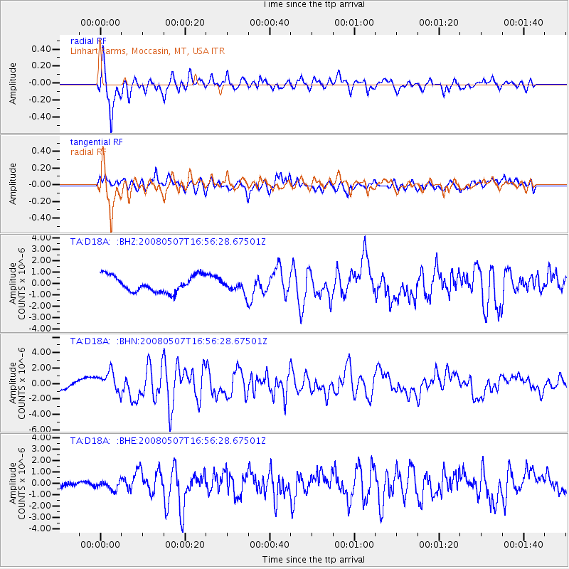
Signal To Noise
| Channel | StoN | STA | LTA |
| TA:D18A: :BHN:20080507T16:56:28.67501Z | 1.9506932 | 1.3580154E-6 | 6.961707E-7 |
| TA:D18A: :BHE:20080507T16:56:28.67501Z | 0.82054263 | 3.60353E-7 | 4.3916427E-7 |
| TA:D18A: :BHZ:20080507T16:56:28.67501Z | 0.87081116 | 6.10762E-7 | 7.0137133E-7 |
| Arrivals |
| Ps | 8.3 SECOND |
| PpPs | 23 SECOND |
| PsPs/PpSs | 32 SECOND |


