You are here: Home > Network List > CI - Caltech Regional Seismic Network Stations List
> Station MPP McPhearson Peak > Earthquake Result Viewer
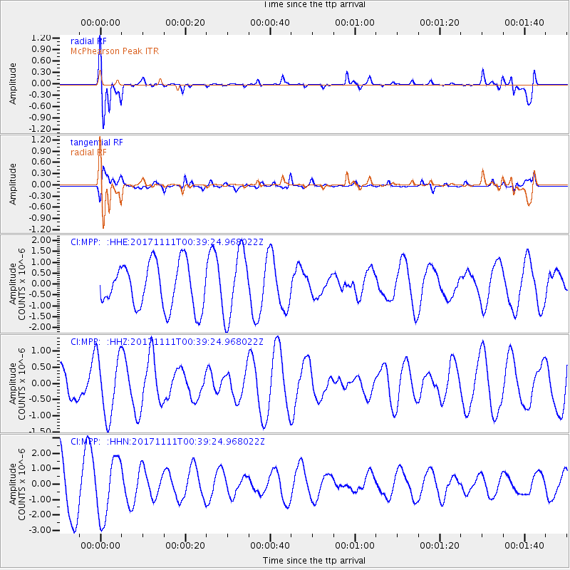
MPP McPhearson Peak - Earthquake Result Viewer
*The percent match for this event was below the threshold and hence no stack was calculated.
| Earthquake location: |
Loyalty Islands |
| Earthquake latitude/longitude: |
-21.4/168.5 |
| Earthquake time(UTC): |
2017/11/11 (315) 00:27:05 GMT |
| Earthquake Depth: |
8.4 km |
| Earthquake Magnitude: |
5.3 Mww |
| Earthquake Catalog/Contributor: |
NEIC PDE/us |
|
| Network: |
CI Caltech Regional Seismic Network |
| Station: |
MPP McPhearson Peak |
| Lat/Lon: |
34.89 N/119.81 W |
| Elevation: |
1739 m |
|
| Distance: |
88.0 deg |
| Az: |
51.337 deg |
| Baz: |
242.264 deg |
| Ray Param: |
$rayparam |
*The percent match for this event was below the threshold and hence was not used in the summary stack. |
|
| Radial Match: |
61.81806 % |
| Radial Bump: |
400 |
| Transverse Match: |
57.537205 % |
| Transverse Bump: |
400 |
| SOD ConfigId: |
13570011 |
| Insert Time: |
2019-04-29 04:15:23.282 +0000 |
| GWidth: |
2.5 |
| Max Bumps: |
400 |
| Tol: |
0.001 |
|
Signal To Noise
| Channel | StoN | STA | LTA |
| CI:MPP: :HHZ:20171111T00:39:24.968022Z | 1.5472472 | 9.3235565E-7 | 6.0259E-7 |
| CI:MPP: :HHN:20171111T00:39:24.968022Z | 1.2910502 | 1.9239285E-6 | 1.4902042E-6 |
| CI:MPP: :HHE:20171111T00:39:24.968022Z | 1.5275209 | 1.5506733E-6 | 1.015157E-6 |
| Arrivals |
| Ps | |
| PpPs | |
| PsPs/PpSs | |


