You are here: Home > Network List > TA - USArray Transportable Network (new EarthScope stations) Stations List
> Station D18A Linhart Farms, Moccasin, MT, USA > Earthquake Result Viewer
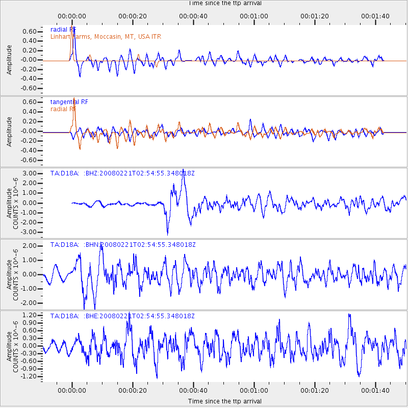
D18A Linhart Farms, Moccasin, MT, USA - Earthquake Result Viewer

| Earthquake location: |
Svalbard Region |
| Earthquake latitude/longitude: |
77.1/18.6 |
| Earthquake time(UTC): |
2008/02/21 (052) 02:46:17 GMT |
| Earthquake Depth: |
10 km |
| Earthquake Magnitude: |
5.7 MB, 5.9 MS, 6.1 MW, 6.0 MW |
| Earthquake Catalog/Contributor: |
WHDF/NEIC |
|
| Network: |
TA USArray Transportable Network (new EarthScope stations) |
| Station: |
D18A Linhart Farms, Moccasin, MT, USA |
| Lat/Lon: |
47.20 N/109.80 W |
| Elevation: |
1202 m |
|
| Distance: |
51.9 deg |
| Az: |
317.187 deg |
| Baz: |
12.959 deg |
| Ray Param: |
0.067126125 |
| Estimated Moho Depth: |
40.25 km |
| Estimated Crust Vp/Vs: |
1.73 |
| Assumed Crust Vp: |
6.518 km/s |
| Estimated Crust Vs: |
3.773 km/s |
| Estimated Crust Poisson's Ratio: |
0.25 |
|
| Radial Match: |
80.1904 % |
| Radial Bump: |
400 |
| Transverse Match: |
70.60111 % |
| Transverse Bump: |
400 |
| SOD ConfigId: |
2564 |
| Insert Time: |
2010-03-06 06:12:11.638 +0000 |
| GWidth: |
2.5 |
| Max Bumps: |
400 |
| Tol: |
0.001 |
|
Signal To Noise
| Channel | StoN | STA | LTA |
| TA:D18A: :BHN:20080221T02:54:55.348018Z | 3.0386095 | 1.0600357E-6 | 3.4885554E-7 |
| TA:D18A: :BHE:20080221T02:54:55.348018Z | 1.2218623 | 2.7203325E-7 | 2.226382E-7 |
| TA:D18A: :BHZ:20080221T02:54:55.348018Z | 8.605385 | 1.2722385E-6 | 1.4784213E-7 |
| Arrivals |
| Ps | 4.8 SECOND |
| PpPs | 16 SECOND |
| PsPs/PpSs | 21 SECOND |


