You are here: Home > Network List > YN10 - San Jacinto Fault Zone Stations List
> Station JORD JORD > Earthquake Result Viewer
JORD JORD - Earthquake Result Viewer
| Earthquake location: |
Loyalty Islands |
| Earthquake latitude/longitude: |
-21.4/168.5 |
| Earthquake time(UTC): |
2017/11/11 (315) 00:27:05 GMT |
| Earthquake Depth: |
8.4 km |
| Earthquake Magnitude: |
5.3 Mww |
| Earthquake Catalog/Contributor: |
NEIC PDE/us |
|
| Network: |
YN San Jacinto Fault Zone |
| Station: |
JORD JORD |
| Lat/Lon: |
33.47 N/116.64 W |
| Elevation: |
1235 m |
|
| Distance: |
89.7 deg |
| Az: |
53.783 deg |
| Baz: |
244.084 deg |
| Ray Param: |
0.041723073 |
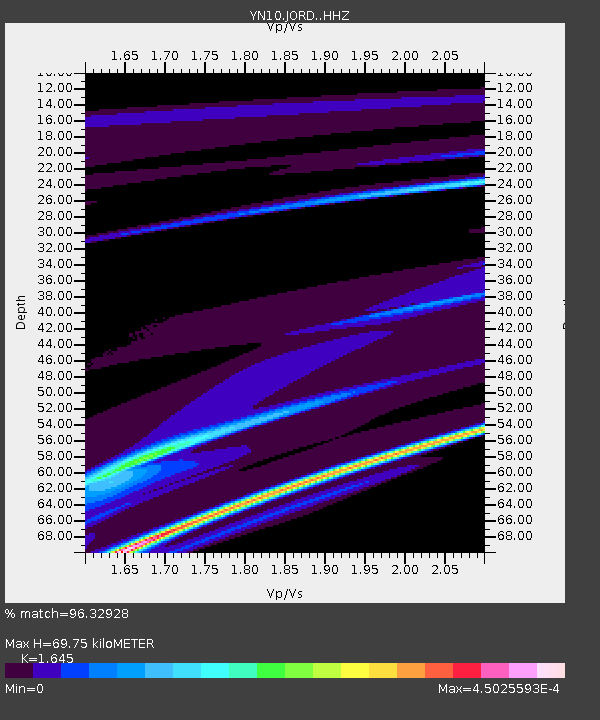
| Estimated Moho Depth: |
69.75 km |
| Estimated Crust Vp/Vs: |
1.64 |
| Assumed Crust Vp: |
6.264 km/s |
| Estimated Crust Vs: |
3.808 km/s |
| Estimated Crust Poisson's Ratio: |
0.21 |
|
| Radial Match: |
96.32928 % |
| Radial Bump: |
66 |
| Transverse Match: |
97.07352 % |
| Transverse Bump: |
188 |
| SOD ConfigId: |
13570011 |
| Insert Time: |
2019-04-29 04:18:13.684 +0000 |
| GWidth: |
2.5 |
| Max Bumps: |
400 |
| Tol: |
0.001 |
|

Signal To Noise
| Channel | StoN | STA | LTA |
| YN:JORD: :HHZ:20171111T00:39:32.979009Z | 1.673512 | 0.0066537196 | 0.003975902 |
| YN:JORD: :HHN:20171111T00:39:32.979009Z | 1.7089411 | 1.1877476E-5 | 6.950196E-6 |
| YN:JORD: :HHE:20171111T00:39:32.979009Z | 1.2815129 | 6.836977E-6 | 5.3350823E-6 |
| Arrivals |
| Ps | 7.3 SECOND |
| PpPs | 29 SECOND |
| PsPs/PpSs | 36 SECOND |


