You are here: Home > Network List > TA - USArray Transportable Network (new EarthScope stations) Stations List
> Station D18A Linhart Farms, Moccasin, MT, USA > Earthquake Result Viewer
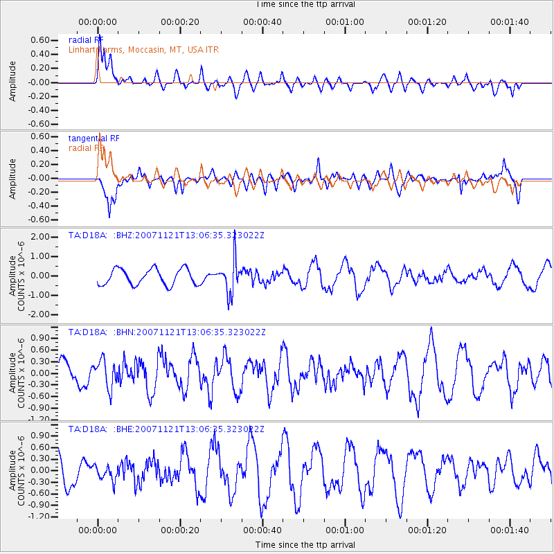
D18A Linhart Farms, Moccasin, MT, USA - Earthquake Result Viewer

| Earthquake location: |
Chile-Argentina Border Region |
| Earthquake latitude/longitude: |
-24.8/-68.5 |
| Earthquake time(UTC): |
2007/11/21 (325) 12:55:05 GMT |
| Earthquake Depth: |
115 km |
| Earthquake Magnitude: |
5.6 MB, 5.8 MW, 5.8 MW |
| Earthquake Catalog/Contributor: |
WHDF/NEIC |
|
| Network: |
TA USArray Transportable Network (new EarthScope stations) |
| Station: |
D18A Linhart Farms, Moccasin, MT, USA |
| Lat/Lon: |
47.20 N/109.80 W |
| Elevation: |
1202 m |
|
| Distance: |
80.8 deg |
| Az: |
332.855 deg |
| Baz: |
142.555 deg |
| Ray Param: |
0.04777957 |
| Estimated Moho Depth: |
23.0 km |
| Estimated Crust Vp/Vs: |
1.91 |
| Assumed Crust Vp: |
6.518 km/s |
| Estimated Crust Vs: |
3.413 km/s |
| Estimated Crust Poisson's Ratio: |
0.31 |
|
| Radial Match: |
82.04594 % |
| Radial Bump: |
400 |
| Transverse Match: |
76.71641 % |
| Transverse Bump: |
400 |
| SOD ConfigId: |
2564 |
| Insert Time: |
2010-03-06 06:12:32.092 +0000 |
| GWidth: |
2.5 |
| Max Bumps: |
400 |
| Tol: |
0.001 |
|
Signal To Noise
| Channel | StoN | STA | LTA |
| TA:D18A: :BHN:20071121T13:06:35.323022Z | 1.2631029 | 3.5693267E-7 | 2.8258398E-7 |
| TA:D18A: :BHE:20071121T13:06:35.323022Z | 0.2937913 | 1.8696485E-7 | 6.363867E-7 |
| TA:D18A: :BHZ:20071121T13:06:35.323022Z | 2.0969145 | 8.6276066E-7 | 4.1144293E-7 |
| Arrivals |
| Ps | 3.3 SECOND |
| PpPs | 10 SECOND |
| PsPs/PpSs | 13 SECOND |


