You are here: Home > Network List > TA - USArray Transportable Network (new EarthScope stations) Stations List
> Station D18A Linhart Farms, Moccasin, MT, USA > Earthquake Result Viewer
D18A Linhart Farms, Moccasin, MT, USA - Earthquake Result Viewer
| Earthquake location: |
Near East Coast Of Honshu, Japan |
| Earthquake latitude/longitude: |
35.5/140.9 |
| Earthquake time(UTC): |
2009/06/06 (157) 05:52:43 GMT |
| Earthquake Depth: |
34 km |
| Earthquake Magnitude: |
5.8 MB, 5.4 MS, 5.8 MW, 5.7 MW |
| Earthquake Catalog/Contributor: |
WHDF/NEIC |
|
| Network: |
TA USArray Transportable Network (new EarthScope stations) |
| Station: |
D18A Linhart Farms, Moccasin, MT, USA |
| Lat/Lon: |
47.20 N/109.80 W |
| Elevation: |
1202 m |
|
| Distance: |
76.2 deg |
| Az: |
41.519 deg |
| Baz: |
307.505 deg |
| Ray Param: |
0.05111823 |
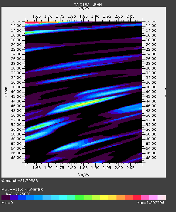
| Estimated Moho Depth: |
11.0 km |
| Estimated Crust Vp/Vs: |
1.62 |
| Assumed Crust Vp: |
6.518 km/s |
| Estimated Crust Vs: |
4.03 km/s |
| Estimated Crust Poisson's Ratio: |
0.19 |
|
| Radial Match: |
81.70888 % |
| Radial Bump: |
400 |
| Transverse Match: |
72.62891 % |
| Transverse Bump: |
400 |
| SOD ConfigId: |
2648 |
| Insert Time: |
2010-03-06 06:13:00.411 +0000 |
| GWidth: |
2.5 |
| Max Bumps: |
400 |
| Tol: |
0.001 |
|

Signal To Noise
| Channel | StoN | STA | LTA |
| TA:D18A: :BHN:20090606T06:03:57.000012Z | 9.083895 | 6.425372E-7 | 7.073367E-8 |
| TA:D18A: :BHE:20090606T06:03:57.000012Z | 2.4892075 | 2.859808E-7 | 1.14888294E-7 |
| TA:D18A: :BHZ:20090606T06:03:57.000012Z | 2.636355 | 2.228153E-7 | 8.451643E-8 |
| Arrivals |
| Ps | 1.1 SECOND |
| PpPs | 4.3 SECOND |
| PsPs/PpSs | 5.3 SECOND |


