You are here: Home > Network List > TA - USArray Transportable Network (new EarthScope stations) Stations List
> Station D18A Linhart Farms, Moccasin, MT, USA > Earthquake Result Viewer
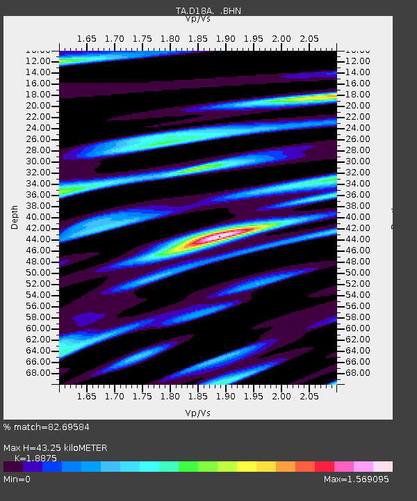
D18A Linhart Farms, Moccasin, MT, USA - Earthquake Result Viewer
| Earthquake location: |
Honduras |
| Earthquake latitude/longitude: |
15.8/-86.9 |
| Earthquake time(UTC): |
2009/06/08 (159) 05:13:14 GMT |
| Earthquake Depth: |
10 km |
| Earthquake Magnitude: |
5.5 MB, 4.9 MS, 5.4 MW, 5.4 MW |
| Earthquake Catalog/Contributor: |
WHDF/NEIC |
|
| Network: |
TA USArray Transportable Network (new EarthScope stations) |
| Station: |
D18A Linhart Farms, Moccasin, MT, USA |
| Lat/Lon: |
47.20 N/109.80 W |
| Elevation: |
1202 m |
|
| Distance: |
36.6 deg |
| Az: |
333.553 deg |
| Baz: |
141.042 deg |
| Ray Param: |
0.07657228 |
| Estimated Moho Depth: |
43.25 km |
| Estimated Crust Vp/Vs: |
1.89 |
| Assumed Crust Vp: |
6.518 km/s |
| Estimated Crust Vs: |
3.453 km/s |
| Estimated Crust Poisson's Ratio: |
0.30 |
|
| Radial Match: |
82.69584 % |
| Radial Bump: |
400 |
| Transverse Match: |
67.8536 % |
| Transverse Bump: |
400 |
| SOD ConfigId: |
2648 |
| Insert Time: |
2010-03-06 06:13:04.011 +0000 |
| GWidth: |
2.5 |
| Max Bumps: |
400 |
| Tol: |
0.001 |
|

Signal To Noise
| Channel | StoN | STA | LTA |
| TA:D18A: :BHN:20090608T05:19:50.375007Z | 8.8808975 | 6.233855E-7 | 7.019397E-8 |
| TA:D18A: :BHE:20090608T05:19:50.375007Z | 2.410629 | 3.5964823E-7 | 1.4919269E-7 |
| TA:D18A: :BHZ:20090608T05:19:50.375007Z | 3.3549738 | 3.3851197E-7 | 1.0089854E-7 |
| Arrivals |
| Ps | 6.3 SECOND |
| PpPs | 18 SECOND |
| PsPs/PpSs | 24 SECOND |


