You are here: Home > Network List > TA - USArray Transportable Network (new EarthScope stations) Stations List
> Station D18A Linhart Farms, Moccasin, MT, USA > Earthquake Result Viewer
D18A Linhart Farms, Moccasin, MT, USA - Earthquake Result Viewer

| Earthquake location: |
Costa Rica |
| Earthquake latitude/longitude: |
8.5/-83.2 |
| Earthquake time(UTC): |
2009/03/11 (070) 21:03:58 GMT |
| Earthquake Depth: |
17 km |
| Earthquake Magnitude: |
5.7 MB, 5.6 MS, 5.9 MW, 5.8 MW |
| Earthquake Catalog/Contributor: |
WHDF/NEIC |
|
| Network: |
TA USArray Transportable Network (new EarthScope stations) |
| Station: |
D18A Linhart Farms, Moccasin, MT, USA |
| Lat/Lon: |
47.20 N/109.80 W |
| Elevation: |
1202 m |
|
| Distance: |
44.7 deg |
| Az: |
334.287 deg |
| Baz: |
141.0 deg |
| Ray Param: |
0.071722314 |
| Estimated Moho Depth: |
19.25 km |
| Estimated Crust Vp/Vs: |
1.99 |
| Assumed Crust Vp: |
6.518 km/s |
| Estimated Crust Vs: |
3.271 km/s |
| Estimated Crust Poisson's Ratio: |
0.33 |
|
| Radial Match: |
81.89267 % |
| Radial Bump: |
400 |
| Transverse Match: |
53.195827 % |
| Transverse Bump: |
400 |
| SOD ConfigId: |
2658 |
| Insert Time: |
2010-03-06 06:13:05.847 +0000 |
| GWidth: |
2.5 |
| Max Bumps: |
400 |
| Tol: |
0.001 |
|
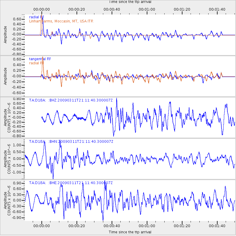
Signal To Noise
| Channel | StoN | STA | LTA |
| TA:D18A: :BHN:20090311T21:11:40.300007Z | 3.5013852 | 5.8427713E-7 | 1.6687028E-7 |
| TA:D18A: :BHE:20090311T21:11:40.300007Z | 0.8179522 | 1.9139762E-7 | 2.3399609E-7 |
| TA:D18A: :BHZ:20090311T21:11:40.300007Z | 1.356956 | 1.723696E-7 | 1.2702667E-7 |
| Arrivals |
| Ps | 3.1 SECOND |
| PpPs | 8.3 SECOND |
| PsPs/PpSs | 11 SECOND |


