You are here: Home > Network List > TA - USArray Transportable Network (new EarthScope stations) Stations List
> Station D18A Linhart Farms, Moccasin, MT, USA > Earthquake Result Viewer
D18A Linhart Farms, Moccasin, MT, USA - Earthquake Result Viewer

| Earthquake location: |
Andreanof Islands, Aleutian Is. |
| Earthquake latitude/longitude: |
51.5/-178.3 |
| Earthquake time(UTC): |
2009/03/30 (089) 12:07:28 GMT |
| Earthquake Depth: |
31 km |
| Earthquake Magnitude: |
6.0 MB, 5.5 MS, 5.7 MW, 5.7 MW |
| Earthquake Catalog/Contributor: |
WHDF/NEIC |
|
| Network: |
TA USArray Transportable Network (new EarthScope stations) |
| Station: |
D18A Linhart Farms, Moccasin, MT, USA |
| Lat/Lon: |
47.20 N/109.80 W |
| Elevation: |
1202 m |
|
| Distance: |
43.3 deg |
| Az: |
67.614 deg |
| Baz: |
302.126 deg |
| Ray Param: |
0.072570756 |
| Estimated Moho Depth: |
11.75 km |
| Estimated Crust Vp/Vs: |
1.60 |
| Assumed Crust Vp: |
6.518 km/s |
| Estimated Crust Vs: |
4.074 km/s |
| Estimated Crust Poisson's Ratio: |
0.18 |
|
| Radial Match: |
88.15056 % |
| Radial Bump: |
400 |
| Transverse Match: |
70.45151 % |
| Transverse Bump: |
400 |
| SOD ConfigId: |
2658 |
| Insert Time: |
2010-03-06 06:13:24.335 +0000 |
| GWidth: |
2.5 |
| Max Bumps: |
400 |
| Tol: |
0.001 |
|
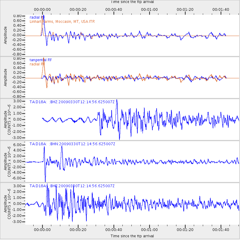
Signal To Noise
| Channel | StoN | STA | LTA |
| TA:D18A: :BHN:20090330T12:14:56.625007Z | 13.467441 | 2.3391135E-6 | 1.7368656E-7 |
| TA:D18A: :BHE:20090330T12:14:56.625007Z | 5.8795176 | 1.3137026E-6 | 2.2343714E-7 |
| TA:D18A: :BHZ:20090330T12:14:56.625007Z | 5.003141 | 1.0518551E-6 | 2.1023892E-7 |
| Arrivals |
| Ps | 1.2 SECOND |
| PpPs | 4.3 SECOND |
| PsPs/PpSs | 5.5 SECOND |


