You are here: Home > Network List > AK - Alaska Regional Network Stations List
> Station DIV Divide Microwave > Earthquake Result Viewer
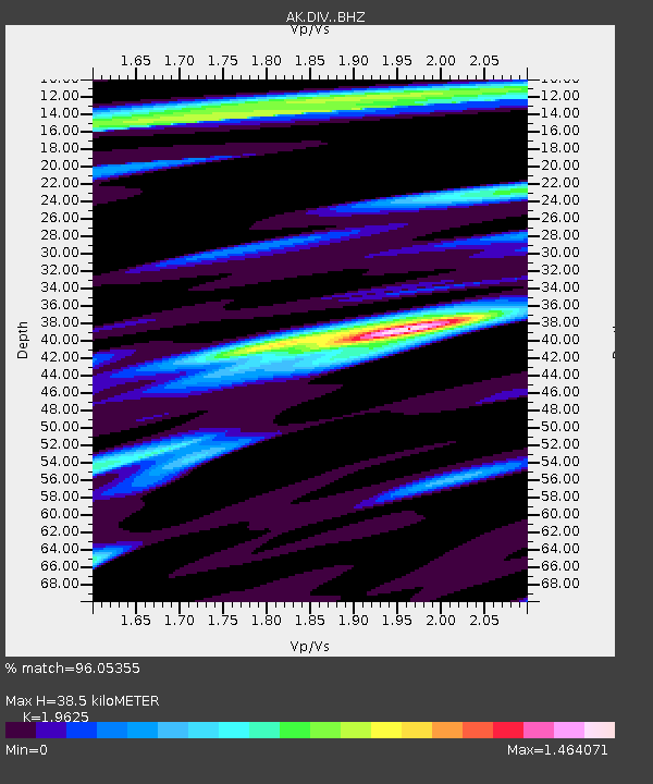
DIV Divide Microwave - Earthquake Result Viewer
| Earthquake location: |
Iran-Iraq Border Region |
| Earthquake latitude/longitude: |
34.9/46.0 |
| Earthquake time(UTC): |
2017/11/12 (316) 18:18:17 GMT |
| Earthquake Depth: |
19 km |
| Earthquake Magnitude: |
7.3 Mww |
| Earthquake Catalog/Contributor: |
NEIC PDE/us |
|
| Network: |
AK Alaska Regional Network |
| Station: |
DIV Divide Microwave |
| Lat/Lon: |
61.13 N/145.77 W |
| Elevation: |
939 m |
|
| Distance: |
83.8 deg |
| Az: |
5.695 deg |
| Baz: |
350.325 deg |
| Ray Param: |
0.045893833 |
| Estimated Moho Depth: |
38.5 km |
| Estimated Crust Vp/Vs: |
1.96 |
| Assumed Crust Vp: |
6.566 km/s |
| Estimated Crust Vs: |
3.346 km/s |
| Estimated Crust Poisson's Ratio: |
0.32 |
|
| Radial Match: |
96.05355 % |
| Radial Bump: |
400 |
| Transverse Match: |
88.83094 % |
| Transverse Bump: |
400 |
| SOD ConfigId: |
13570011 |
| Insert Time: |
2019-04-29 04:25:23.601 +0000 |
| GWidth: |
2.5 |
| Max Bumps: |
400 |
| Tol: |
0.001 |
|

Signal To Noise
| Channel | StoN | STA | LTA |
| AK:DIV: :BHZ:20171112T18:30:13.987998Z | 33.610825 | 1.6484026E-5 | 4.90438E-7 |
| AK:DIV: :BHN:20171112T18:30:13.987998Z | 15.952233 | 6.847626E-6 | 4.2925817E-7 |
| AK:DIV: :BHE:20171112T18:30:13.987998Z | 4.7190533 | 1.1084604E-6 | 2.3489044E-7 |
| Arrivals |
| Ps | 5.8 SECOND |
| PpPs | 17 SECOND |
| PsPs/PpSs | 23 SECOND |


